Stanser Joch, Mountain summit in Tyrol, Austria
Stanser Joch is a 2102 m summit in the Karwendel range of Tyrol, the eastern end of the Rauer Knöll branch east of the Hinterautal-Vomper chain. It is a barely distinct rise on a long ridge running east from the Ochsenkopf (2148 m); the name also covers the whole flat ridge between the Weißenbachtal to the north and the Stallental and Inntal to the south. Its south side falls in fairly even slopes, while to the Weißenbachtal it breaks off steeply.
In 1868 Adolf Pichler found older rocks lying in furrows on the crest of the Stanser Joch anticline. Otto Ampferer read this as a relief overthrust, recognising erosion as a factor in tectonics; today the structure is explained as a southwest-directed back-thrust from the Tertiary. Avalanches from the mountain killed 24 people on 3 February 1689, and between 1986 and 1991 4,450 metres of supporting structures and 636 metres of snow fences were built in the starting zone at a cost of 43 million schillings.
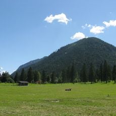
The name Stanser Joch refers not only to the 2102 m summit but to the whole flat ridge above the village of Stans. The Stanser Alm on the south side is still used as pasture, with a Niederleger at 1355 m and a Hochleger at 1961 m. A gravel road leads up to the alpine huts, and walkers share the route with grazing cattle in summer.
Several hiking trails lead to the summit with varying difficulty levels and lengths. The best time to hike is from May through October when snow has melted and routes are accessible.
The ridge's crest is a tilted arch of Wetterstein limestone: in 1868 Adolf Pichler found much older rock lying in furrows on top of it. Otto Ampferer read this as a relief overthrust, making erosion a factor in tectonics; today it is explained as a southwest-directed back-thrust from the Tertiary.
The community of curious travelers
AroundUs brings together thousands of curated places, local tips, and hidden gems, enriched daily by 93,791 contributors worldwide.