Strathroy-Caradoc, Municipality in Middlesex County, Ontario, Canada
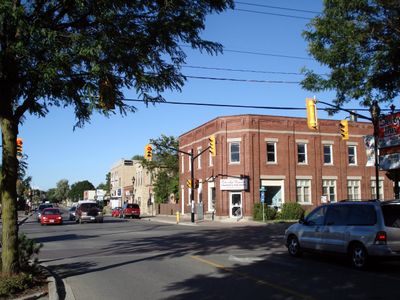
The municipality spans across 270 square kilometers of land, combining urban settlements with agricultural areas in southwestern Ontario near London.
Founded in 1832 by John Stewart Buchanan, Strathroy developed from a small settlement to merge with Caradoc Township in 2001, forming the current municipality.
The municipality maintains a strong agricultural identity through local farms, processing facilities, and annual celebrations centered around turkey production and farming traditions.
The municipal offices at 8081 Falconbridge Drive provide administrative services to 23,871 residents, with direct access to Highway 402 for regional connections.
Three major railway lines intersect within the municipality, contributing to its role as a transportation hub for agricultural and industrial products.
Location: Middlesex County
Inception: 1832
Shares border with: Adelaide Metcalfe, Middlesex Centre, Southwest Middlesex
Website: http://strathroy-caradoc.ca
GPS coordinates: 42.91083,-81.53306
Latest update: May 27, 2025 11:33
Springbank Park
18 km
TD Waterhouse Stadium
23.3 km
Museum of Ontario Archaeology
21.8 km
Hume Cronyn Memorial Observatory
23.5 km
London Regional Children's Museum
23.3 km
Caradoc Sands
6.5 km
Flint Cottage and Springbank Shelter
17.8 km
Komoka Provincial Park
11.9 km
Grosvenor Lodge
23.2 km
Philip Aziz Property
23.3 km
Brick Street Cemetery
21.2 km
Plan of Woodside Survey, London South, Property of Charles Hutchinson, Esq're
23.3 km
Scottsville Cemetery
20 km
Plan (in pencil) of property in the Village of Petersville
23.5 km
Map of the site of proposed waterworks for the City of London at Coombs Mills & Byron, Broken Front Con'sn, Westminster
19.9 km
63 Elmwood Avenue East
23.3 km
Elsie-Perrin Williams Estate
22.6 km
Cook's United Church
4.1 km
Norton Attawandaron Archaeological Site
21.7 km
35 Elmwood Avenue East
23.2 km
26 Bruce Street
23.2 km
64 Elmwood Avenue East
23.4 km
70 Elmwood Avenue East
23.4 km
Chestnut Hill
22.5 km
86 Askin Street
23.6 km
87 Askin Street
23.6 km
School Reserve in the Broken Front of Westminster
22.8 km
Map of Kensal Park, London, Ontario
22.4 kmReviews
Visited this place? Tap the stars to rate it and share your experience / photos with the community! Try now! You can cancel it anytime.
Discover hidden gems everywhere you go!
From secret cafés to breathtaking viewpoints, skip the crowded tourist spots and find places that match your style. Our app makes it easy with voice search, smart filtering, route optimization, and insider tips from travelers worldwide. Download now for the complete mobile experience.
A unique approach to discovering new places❞
— Le Figaro
All the places worth exploring❞
— France Info
A tailor-made excursion in just a few clicks❞
— 20 Minutes