Enable Location

We need your location to show you interesting places around you

Discover nearby places

Find interesting locations and hidden gems around you

Precise directions

Get accurate directions and distances to places

Your location is never shared with other users. It's only used when you tap the location button.

Décarie Interchange

Log in to your account

Start exploring — it's free

Trusted by 63,362 travelers worldwide

Continue with Google
Continue with Apple
or

We will send you a code to connect

By continuing, you accept our Terms and Conditions and our Privacy Policy

Check your inbox

We've sent a pincode in your inbox. Please enter the code below.

Décarie Interchange
Discussion Reviews 1 Photos
2.1k Popularity

Décarie Interchange, Highway interchange in Montreal, Canada.

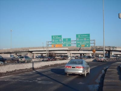
The Décarie Interchange is a multi-level highway junction connecting Autoroute 15, Autoroute 20, and Route 136 in Montreal's road network. The facility uses a turbine-like design with stacked roadways and elevated ramps that channel traffic efficiently between the north and south of the city.

The interchange was built during Montreal's infrastructure expansion in the 1960s to prepare the city for the 1967 Expo international exhibition. Construction was part of a broader transportation renewal program that readied the city for a major global event.

The structure takes its name from the Décarie family, whose member Daniel-Jérémie served as mayor of Notre-Dame-de-Grâce from 1877 to 1904. This naming reflects the area's local heritage and continues to define the identity of this major junction.

This is a heavily trafficked junction best viewed during off-peak hours if you want to observe the structure itself without distraction. The best vantage points are from the surrounding local roads, where you can see the stacked design and complex ramp system clearly.

Engineers designed the interchange with intentional height variations across different levels to optimize traffic flow while meeting noise reduction standards. This elevation system was specifically calculated to reduce noise that would otherwise reach the nearby residential neighborhoods.

The community of curious travelers

AroundUs brings together thousands of curated places, local tips, and hidden gems, enriched daily by 60,000 contributors worldwide.

Start exploring
Location
Official opening
1960
GPS coordinates
45.50370,-73.66630
Latest update
December 13, 2025 17:01
Reviews
Share your experience

No review yet

Discussions
Start a discussion...

No discussion yet

« Décarie Interchange - Highway interchange in Montreal, Canada » is provided by Around Us (aroundus.com). Images and texts are derived from Wikimedia project under a Creative Commons license. You are allowed to copy, distribute, and modify copies of this page, under the conditions set by the license, as long as this note is clearly visible.

Discover hidden gems everywhere you go!

From secret cafés to breathtaking viewpoints, skip the crowded tourist spots and find places that match your style. Our app makes it easy with voice search, smart filtering, route optimization, and insider tips from travelers worldwide. Download now for the complete mobile experience.

Around Us App Screenshot

A unique approach to discovering new places

Le Figaro

All the places worth exploring

France Info

A tailor-made excursion in just a few clicks

20 Minutes

Around Us
Travel Guide & Maps
Download

Send to your phone

QR Code
1

Open the camera app on your mobile.

2

Point at the QR code with your camera. A notification will appear.

3

Tap the notification to open the link.