Enable Location

We need your location to show you interesting places around you

Discover nearby places

Find interesting locations and hidden gems around you

Precise directions

Get accurate directions and distances to places

Your location is never shared with other users. It's only used when you tap the location button.

Log in to your account

Start exploring — it's free

Trusted by 63,409 travelers worldwide

Continue with Google
Continue with Apple
or

We will send you a code to connect

By continuing, you accept our Terms and Conditions and our Privacy Policy

Check your inbox

We've sent a pincode in your inbox. Please enter the code below.

Wabigoon Lake
Discussion Reviews Photo
2.2k Popularity

Wabigoon Lake, lake in Kenora District, Ontario, Canada

Wabigoon Lake is a large body of water in northwestern Ontario that stretches across a wide area and is surrounded by forest and rocky islands. A dam built long ago controls the water level and changed the landscape around the lake by raising the surface and affecting plant growth.

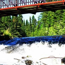
The lake was originally used by Ojibwe people for fishing and travel and was central to their way of life. Over time, a dam was built to power a paper mill, raising the water level and displacing wild rice patches that were once abundant and provided food for animals and people.

The lake's name comes from the Ojibwe language, meaning 'marigold' or 'white feather,' reflecting the plant and bird life of the region. Visitors walking the shoreline can see how the water and surrounding forest are closely connected in the daily life of the area.

The lake sits in a forest setting with varying shorelines featuring bays, beaches, and rocky points that offer different access points for visitors. Depths vary from shallow areas to deeper spots, making it suitable for fishing, boating, canoeing, and shore walks at different times of year.

The lake was once surrounded by abundant wild rice patches that provided food for animals and people, but these were displaced when the dam was built. Visitors today can observe how major engineering projects have fundamentally changed the natural landscape and ecosystem of the region.

The community of curious travelers

AroundUs brings together thousands of curated places, local tips, and hidden gems, enriched daily by 60,000 contributors worldwide.

Start exploring
Location
Elevation above the sea
367 m
GPS coordinates
49.75000,-92.70000
Latest update
February 9, 2026 08:21
Reviews
Share your experience

No review yet

Discussions
Start a discussion...

No discussion yet

« Wabigoon Lake - lake in Kenora District, Ontario, Canada » is provided by Around Us (aroundus.com). Images and texts are derived from Wikimedia project under a Creative Commons license. You are allowed to copy, distribute, and modify copies of this page, under the conditions set by the license, as long as this note is clearly visible.

Discover hidden gems everywhere you go!

From secret cafés to breathtaking viewpoints, skip the crowded tourist spots and find places that match your style. Our app makes it easy with voice search, smart filtering, route optimization, and insider tips from travelers worldwide. Download now for the complete mobile experience.

Around Us App Screenshot

A unique approach to discovering new places

Le Figaro

All the places worth exploring

France Info

A tailor-made excursion in just a few clicks

20 Minutes

Around Us
Travel Guide & Maps
Download

Send to your phone

QR Code
1

Open the camera app on your mobile.

2

Point at the QR code with your camera. A notification will appear.

3

Tap the notification to open the link.