Chest opened
+${chestReward.xp} XP
Explorer
NOUVEAU ×${chestReward.collectible.quantity}
tapez pour fermer
Chest locked

Open chests in the app

Around Us is built for your phone — chests unlock when you walk, explore and capture nearby places.

Enable Location

We need your location to show you interesting places around you

Discover nearby places

Find interesting locations and hidden gems around you

Precise directions

Get accurate directions and distances to places

Your location is never shared with other users. It's only used when you tap the location button.

Lualaba River

Log in to your account

Start exploring — it's free

Trusted by 72,886 travelers worldwide

Continue with Google
Continue with Apple
or

We will send you a code to connect

By continuing, you accept our Terms and Conditions and our Privacy Policy

Check your inbox

We've sent a pincode in your inbox. Please enter the code below.

Lualaba River
Discussion Reviews 2 Photos
20.7k Popularity

Lualaba River, Major river system in eastern Democratic Republic of the Congo.

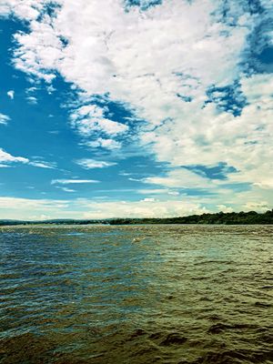
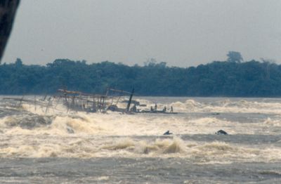
The Lualaba River flows northward through eastern regions, connecting varied landscapes from its source to where it merges with the Congo. The waterway serves as a navigation route but is interrupted in places by rapids.

The river gained attention in the 19th century when expeditions investigated its geographical role in the region. These explorations helped clarify how the river system connected to other major waterways.

Local communities along the banks have developed fishing methods passed down through generations that work with the river's seasonal rhythms. This knowledge shapes how people interact with the water in their everyday lives.

The best way to explore is to use the navigable sections and rely on local knowledge about rapids and crossing points. If you need to move between different banks, find out beforehand about available crossing options.

The water flows over significant mineral deposits in several locations, giving the region economic importance. This geological feature makes the river notable for different reasons beyond simple navigation.

The community of curious travelers

AroundUs brings together thousands of curated places, local tips, and hidden gems, enriched daily by 60,000 contributors worldwide.

Start exploring
GPS coordinates
2.14778,22.48194
Latest update
December 7, 2025 10:05
Around this place
St. Peter Claver Cathedral, Bangassou
Central African Republic

St. Peter Claver Cathedral, Bangassou

291.6 km
Congo, Democratic Republic of the

Luo Scientific Reserve

223.7 km
Congo, Democratic Republic of the

Kokolopori Bonobo Reserve

250.9 km
Congo, Democratic Republic of the

Lomako-Yokokala Nature Reserve

186 km
Central African Republic

Kembé Falls

283.9 km
Congo, Democratic Republic of the

Chute Maiwangu

212.6 km
Congo, Democratic Republic of the

Chutes de la Wulama

286.4 km
Congo, Democratic Republic of the

Luabo cote gwaka village 3

282.7 km
Congo, Democratic Republic of the

Memorial

158.6 km
Congo, Democratic Republic of the

Luabo cote gwaka village

282.7 km
Congo, Democratic Republic of the

Luabo côté gwaka village 5

282.5 km
Congo, Democratic Republic of the

Luabo côté gwaka village 6

282.5 km
Congo, Democratic Republic of the

Jonction luabo maman alobi

282.7 km
Congo, Democratic Republic of the

Luabo gwaka village 1

282.7 km
Congo, Democratic Republic of the

Rivieré luabo cote wenze

285.2 km
Congo, Democratic Republic of the

Luabo cote gwaka village 2

282.7 km
Congo, Democratic Republic of the

Luabo cote gwaka village 4

282.6 km
Congo, Democratic Republic of the

Bifurcation Movenda

130.6 km
Congo, Democratic Republic of the

Maman Alobi

281.3 km
Central African Republic

Kembé Falls

283.9 km
Central African Republic

Waterfall

294.4 km
Central African Republic

Waterfall

293.5 km
Central African Republic

Waterfall

294.4 km
Central African Republic

Waterfall

294 km
Central African Republic

Waterfall

294.1 km
Central African Republic

Waterfall

293.5 km
Central African Republic

Waterfall

293.5 km
Central African Republic

Waterfall

293.6 km
Show the full map
Reviews
Share your experience

No review yet

Discussions
Start a discussion...

No discussion yet

« Lualaba River - Major river system in eastern Democratic Republic of the Congo » is provided by Around Us (aroundus.com). Images and texts are derived from Wikimedia project under a Creative Commons license. You are allowed to copy, distribute, and modify copies of this page, under the conditions set by the license, as long as this note is clearly visible.

Discover hidden gems everywhere you go!

From secret cafés to breathtaking viewpoints, skip the crowded tourist spots and find places that match your style. Our app makes it easy with voice search, smart filtering, route optimization, and insider tips from travelers worldwide. Download now for the complete mobile experience.

Around Us App Screenshot

A unique approach to discovering new places

Le Figaro

All the places worth exploring

France Info

A tailor-made excursion in just a few clicks

20 Minutes

Around Us
Travel Guide & Maps
Download

Send to your phone

QR Code
1

Open the camera app on your mobile.

2

Point at the QR code with your camera. A notification will appear.

3

Tap the notification to open the link.