Tweralpspitz, Mountain summit in canton St. Gallen, Switzerland.
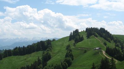
Tweralpspitz is a mountain summit in the eastern Swiss plateau at 1,331 meters high. It sits as the highest point in a ridgeline that runs north of Ricken Pass and overlooks the valleys of Wattwil and surrounding farmland.
The summit has long served as a natural landmark for navigation and geographical reference in the eastern Swiss plateau. Early mapmakers and explorers used it as a recognizable feature when surveying the surrounding region.
Local farmers maintain traditional alpine agricultural practices on the lower slopes of Tweralpspitz, preserving centuries-old methods of land management.
Marked hiking trails connect the summit to nearby villages like Wattwil and Hintergoldingen with routes of moderate length. Weather conditions change quickly in the mountains, so it is wise to check forecasts and bring layers before setting out.
As visitors climb toward the top, they encounter Nagelfluh rock formations, a distinctive conglomerate made of Alpine pebbles and limestone cemented together. This stone type shapes the appearance of the entire slope and tells the geological story of how the eastern plateau formed.
The community of curious travelers
AroundUs brings together thousands of curated places, local tips, and hidden gems, enriched daily by 60,000 contributors worldwide.