Western Pomerania-Rügen District
Western Pomerania-Rügen District, Rural district with Baltic Sea coastline in Mecklenburg-Western Pomerania, Germany.
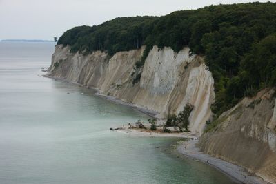
Western Pomerania-Rügen is an administrative district on the Baltic Sea coast with extended sandy beaches, shallow lagoons, and steep cliffs. The largest German island, Rügen, forms a significant part of this region with its distinctive white chalk formations.
The district was created in 2011 through a merger combining several former administrative regions and the Hanseatic city of Stralsund. This reorganization brought together separated coastal territories under a single administrative structure.
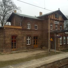
Coastal settlements here reflect a maritime way of life rooted in fishing traditions. Visitors can observe this connection to the sea in how locals use the harbors and waterfront spaces daily.
The region is easily accessible by car and has several small airports plus numerous harbors for boat trips. Visitors will find many access points along the coast for both water-based and land activities.
The Fischland-Darß-Zingst area formed through natural sand deposits and attracts regular bird migrations that sweep across these narrow peninsulas. These strips of land reveal how coastal forces continuously reshape the shoreline.
Location: Mecklenburg-Western Pomerania
Inception: September 4, 2011
Capital city: Stralsund
Shares border with: Rostock District, Mecklenburgische Seenplatte District, Vorpommern-Greifswald District
Website: https://lk-vr.de
GPS coordinates: 54.25000,13.02000
Latest update: December 6, 2025 21:21
Stralsund Hauptbahnhof
7.6 km
Paul-Greifzu-Stadion
7.3 km
Kirche Voigdehagen
5.3 km
Auferstehungskirche
6.7 km
Lutherkirche in Stralsund
6.4 km
Friedenskirche
6.4 km
Dorfkirche Pütte
5.2 km
Heilgeistkirche
6.6 km
Borgwallsee und Pütter See
5.5 km
Church in Elmenhorst
4.7 km
Church in Steinhagen
3.5 km
Marienstraße 3
7.8 km
Abtshagen
5.2 km
Försterhofer Heide
4.5 km
Tribseer Straße 1
7.8 km
Krummenhagener See
1.2 km
Bleistraße 2 a (Stralsund)
7.9 km
Tribseer Straße 30
7.9 km
Bleistraße 1
7.9 km
Tribseer Straße 7
7.9 km
Marienstraße 4
7.8 km
Bleistraße 14 (Stralsund)
7.9 km
Bleistraße 2
7.9 km
Krummenhagener See, Borgwallsee und Pütter See
1.4 km
Kriegerdenkmal 1914/1918
4.6 km
Bahnhof (Empfangsgebäude, Güterboden)
5.6 km
Försterhofer Heide
4.5 km
Historic center of Stralsund
7.2 kmReviews
Visited this place? Tap the stars to rate it and share your experience / photos with the community! Try now! You can cancel it anytime.
Discover hidden gems everywhere you go!
From secret cafés to breathtaking viewpoints, skip the crowded tourist spots and find places that match your style. Our app makes it easy with voice search, smart filtering, route optimization, and insider tips from travelers worldwide. Download now for the complete mobile experience.
A unique approach to discovering new places❞
— Le Figaro
All the places worth exploring❞
— France Info
A tailor-made excursion in just a few clicks❞
— 20 Minutes