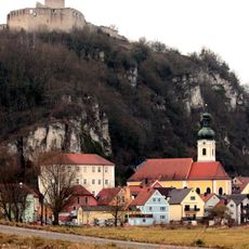
Burgruine Kallmünz, Medieval castle ruins on hilltop in Kallmünz, Germany.
Burgruine Kallmünz stands on the Schlossberg spur at 433 m, above the confluence of the Vils and Naab. The core castle sits at the tip of the ridge: a 20 m round bergfried with a high entrance 8 m up, walls about 2.3 m thick in limestone ashlar, and the multi-sided two-storey palas with paired round-arched windows, two knights' halls and a castle chapel to the north. A sickle-shaped rampart, the Ungarnwall, cuts the spur to the north.
The castle was first named as Wittelsbach property in the 1329 Treaty of Pavia, and in 1358 Rupert I was allowed to redeem it; he had building work carried out from 1361. Bavarian troops burned it in 1504, imperial troops plundered it in 1633, and Swedish troops destroyed it by fire in 1641. From 1793 the ruins belonged to the municipality.
The remaining stonework reveals Gothic design choices that visitors can observe while walking through the site. These elements show how medieval builders created defensive structures and organized castle spaces.
The climb to the ruin follows a path on the Schlossberg; in 2013 plans to mill and resurface the route were opposed because it would have damaged a thousand-year-old archaeological monument. The 20-metre bergfried can be climbed on Sundays and public holidays during the summer opening hours of the castle café below the ruin. The site is one of over 40 castles linked by the Burgensteige trails around Regensburg.
The ring wall with its half-round towers, about 1.2 metres thick, is attributed to construction work that Count Palatine Rupert I had carried out at the castle in 1351. The round keep, 20 metres high with walls some 2.3 metres thick, is entered through a high entrance 8 metres above the ground.
The community of curious travelers
AroundUs brings together thousands of curated places, local tips, and hidden gems, enriched daily by 93,962 contributors worldwide.