Enable Location

We need your location to show you interesting places around you

Discover nearby places

Find interesting locations and hidden gems around you

Precise directions

Get accurate directions and distances to places

Your location is never shared with other users. It's only used when you tap the location button.

Fuelbecketalsperre

Log in to your account

Start exploring — it's free

Trusted by 62,851 travelers worldwide

Continue with Google
Continue with Apple
or

We will send you a code to connect

By continuing, you accept our Terms and Conditions and our Privacy Policy

Check your inbox

We've sent a pincode in your inbox. Please enter the code below.

Fuelbecketalsperre

Fuelbecketalsperre, reservoir

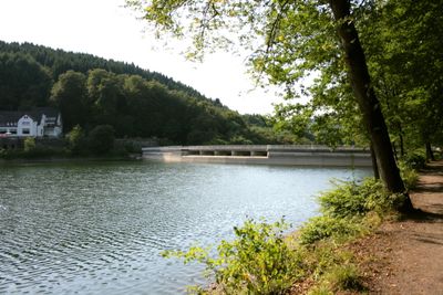
The Fuelbecketalsperre is a small dam in Märkischer Kreis near Altena, built between 1894 and 1896. The stone structure stands about 27 meters tall and 145 meters long, holding roughly 700,000 cubic meters of water, with its basin shaped by two streams flowing in from opposite directions.

The dam was built between 1894 and 1896 and was the first in the Sauerland region. It was created to provide water for local industry in the valleys, especially during dry seasons when natural flow could not sustain mills and factories.

The name derives from the Fuelbecke stream that flows in from the east. Today locals and visitors use the area for peaceful walks and nature watching, valuing it as a quiet retreat in the landscape.

Visitors can walk on marked trails around the water where signs provide information about local fish species. Access is free, but swimming and water sports are not permitted since the water serves the drinking supply.

The structure displays Jugendstil decorative details and was designed by a professor from Aachen using the so-called Intze principle. This innovative building style with its ornamental stone features set the Fuelbecketalsperre apart from other industrial dams of the era.

The community of curious travelers

AroundUs brings together thousands of curated places, local tips, and hidden gems, enriched daily by 60,000 contributors worldwide.

Start exploring
GPS coordinates
51.24830,7.66250
Latest update
February 9, 2026 08:23
« Fuelbecketalsperre - reservoir » is provided by Around Us (aroundus.com). Images and texts are derived from Wikimedia project under a Creative Commons license. You are allowed to copy, distribute, and modify copies of this page, under the conditions set by the license, as long as this note is clearly visible.

Discover hidden gems everywhere you go!

From secret cafés to breathtaking viewpoints, skip the crowded tourist spots and find places that match your style. Our app makes it easy with voice search, smart filtering, route optimization, and insider tips from travelers worldwide. Download now for the complete mobile experience.

Around Us App Screenshot

A unique approach to discovering new places

Le Figaro

All the places worth exploring

France Info

A tailor-made excursion in just a few clicks

20 Minutes

Around Us
Travel Guide & Maps
Download

Send to your phone

QR Code
1

Open the camera app on your mobile.

2

Point at the QR code with your camera. A notification will appear.

3

Tap the notification to open the link.