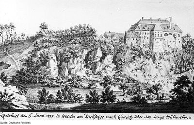
Gröditzer Skala, Protected valley along Löbauer River in Weißenberg, Germany.
The Gröditzer Skala is a protected valley area featuring steep rocky cliffs surrounded by forest and cut through by the Löbauer River. The river winds past limestone formations that support various plant communities across the slopes.
The Löbauer River carved deep into the graywacke bedrock during the glacial period, creating the steep valley walls seen today. This slow process shaped the dramatic relief that makes the area distinctive.
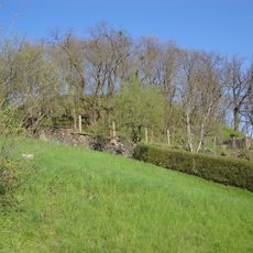
Local landowners shaped this area in the early 19th century by carving classical inscriptions into the rock faces. This reflects how property owners of that era tried to blend culture and nature together.
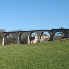
The area is accessible via the Mill Trail, which connects nearby towns and provides good wayfinding through the valley. A restored railway viaduct with multiple arches offers an alternative route if you prefer a more built structure.
South-facing slopes shelter unusual plant species such as mountain maple, large-flowered foxglove, and spurge that are rare elsewhere in the region. These plants thrive in the warm microclimate created by the steep rocky terrain.
Location: Weißenberg
Inception: 1961
Elevation above the sea: 184 m
GPS coordinates: 51.20650,14.63720
Latest update: December 14, 2025 13:07
Kirche Gröditz
913 m
Marktbrunnen
1.8 km
Gröditzer Schanze
878 m
Rathaus Weißenberg
1.8 km
Boundary stones in Hohendubrau
1.7 km
Kirchschule Weißenberg
1.7 km
Kirche Weißenberg
1.8 km
Alte Lohgerberei; Villa mit Einfriedung und Gerberei mit Dampfmaschine Wasserstraße 1, 1a
1.8 km
Niedermühle Weißenberg
1.5 km
Weißenberg, August-Bebel-Platz 11
1.8 km
Wohnstallhaus Hauptstraße 10
747 m
Mittel- oder Dampfmühle Weißenberg
1.5 km
Schloss Gröditz
915 m
Dorfplatz 6
981 m
Sächsisch-Preußischer Grenzstein: Pilarpaar Nr. 60
1.9 km
Cortnitz 16
1.8 km
Viadukt Gröditz
635 m
Alte Pfefferküchlerei
1.8 km
Wohnhaus in offener Bebauung Mühlbergstraße 23
1.6 km
Wohn- und Wirtschaftsgebäude (nördliche Hälfte des Gebäudetraktes), (Einzeldenkmal zu ID-Nr. 09300806) Alter Berg 18
929 m
Cortnitz 8
1.9 km
Gasthof in geschlossener Bebauung August-Bebel-Platz 10
1.8 km
Wohnhaus Mühlbergstraße 10
1.7 km
Wohnhaus in geschlossener Bebauung August-Bebel-Platz 13
1.8 km
Wohnhaus Mühlbergstraße 19
1.6 km
Cortnitz 11
1.8 km
Wohnstallhaus mit Oberlaube Hauptstraße 40
760 m
Wohnstallhaus und Seitengebäude Schellenbergweg 2
722 mVisited this place? Tap the stars to rate it and share your experience / photos with the community! Try now! You can cancel it anytime.
Discover hidden gems everywhere you go!
From secret cafés to breathtaking viewpoints, skip the crowded tourist spots and find places that match your style. Our app makes it easy with voice search, smart filtering, route optimization, and insider tips from travelers worldwide. Download now for the complete mobile experience.
A unique approach to discovering new places❞
— Le Figaro
All the places worth exploring❞
— France Info
A tailor-made excursion in just a few clicks❞
— 20 Minutes