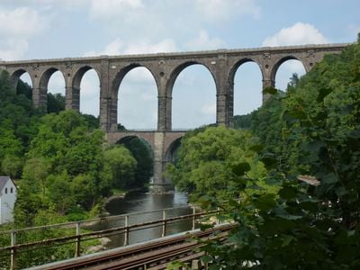
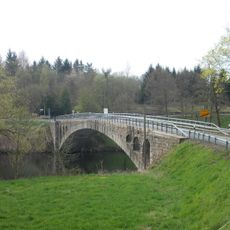
Göhrener Viadukt, Railway viaduct in Wechselburg and Lunzenau, Germany.
The Göhrener Viadukt is a railway viaduct that spans the Zwickauer Mulde valley and features two levels of stone arches. Below the structure, streetcars and other routes pass through the arches.
Construction began in 1869 and was completed in 1871 to carry the Chemnitz-Leipzig railway line across the valley. The project used granite blocks from local quarries in the region.
The structure shows how people in the 19th century crossed valleys and connected distant places. It stands alongside other major stone bridges as proof of what engineering skill could achieve at that time.
You can view the viaduct from several nearby viewpoints that offer free access. The best time to visit is in daylight, when the stone structure is clearly visible.
The stone blocks came from quarries that once operated in Fischheim, Markersdorf, and Göhren nearby. Using local materials made the project more economical and tied the structure directly to the surrounding landscape.
Location: Wechselburg
Location: Lunzenau
Inception: 1869
Address: Göhren
GPS coordinates: 50.98140,12.76920
Latest update: December 8, 2025 19:47
Schlossberg
712 m
Zum Prellbock
2.2 km
St. Katharinen und Georgen
718 m
Villa mit Einfriedung, Eingangstor und Garten Burgstädter Straße 36
1.4 km
Straßenüberführung Burgstädter Straße
2 km
Cossen railway station
1.5 km
Mulden- und Chemnitztal (Anteil Lkr. Mittelsachsen)
1.3 km
Muldenbrücke Lunzenau
2.3 km
Straßenbrücke über die Chemnitz
2.2 km
Vermutlich ehemalige Kattundruckerei mit Wohn- und Verwaltungsräumen, zeitweise Pferdegut, später Mehrfamilienhaus Untere Hauptstraße 5
2.2 km
Stiel-Eiche bei Hohenkirchen
1.9 km
Winter-Linde Göhren
207 m
Zwickauer-Mulden-Brücke Göhren
389 m
Naturdenkmal ND 080 Hainbuche in Göhren
625 m
Wasserhochbehälter und Druckvorrichtung Hartha
1.5 km
Ehemaliger Gasthof mit Saalanbau Oberhohenkirchener Straße 3
2.1 km
Vorwerk Schlaisdorf
2.1 km
Pfarrhof mit Pfarrhaus und zwei Seitengebäuden sowie Einfriedung Oberhohenkirchener Straße 4
2.1 km
Grabstein in Baumstammform
2.1 km
Grufthaus der Familie Jahn, Kriegerdenkmal und Grabstein Dr. Max Vogler
2.2 km
Markt 2
2.3 km
Bahnhof Göritzhain
2.1 km
Wohnhaus in geschlossener Bebauung Friedensstraße 21
2.3 km
Sachgesamtheit Neuer Friedhof Oberhohenkirchener Straße
2 km
Wohnhaus in geschlossener Bebauung und zwei Hinterhäuser Markt 4
2.3 km
Kirche Hohenkirchen
2.1 km
Wohnstallhaus, Seitengebäude und Scheune eines Dreiseithofes sowie Torbogen mit Pforte Alte Straße 7
813 m
Wohnstallhaus und zwei Seitengebäude eines Dreiseithofes und Torbogen Alte Straße 6
837 mVisited this place? Tap the stars to rate it and share your experience / photos with the community! Try now! You can cancel it anytime.
Discover hidden gems everywhere you go!
From secret cafés to breathtaking viewpoints, skip the crowded tourist spots and find places that match your style. Our app makes it easy with voice search, smart filtering, route optimization, and insider tips from travelers worldwide. Download now for the complete mobile experience.
A unique approach to discovering new places❞
— Le Figaro
All the places worth exploring❞
— France Info
A tailor-made excursion in just a few clicks❞
— 20 Minutes