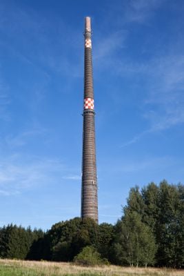
Halsbrücker Esse, Industrial chimney in Halsbrücke, Germany.
The Halsbrücker Esse is a massive industrial smokestack in Halsbrücke that served a smelting works and was built from fired clay bricks. The structure tapers noticeably toward the top and features a solid construction designed to last for many years of heavy use.
The structure was built in the late 1880s in response to growing metal production in the area. Its commissioning marked a phase of industrial expansion in Saxony and the consolidation of production processes in the region.
This smokestack was central to the mining industry of the area and shows how important smelting works were to daily life. The structure still shapes the skyline today and reminds people of when such plants were the economic heart of the region.
The chimney is about 140 meters tall and can be climbed via built-in steps inside and on the outside. Ascending requires a good head for heights and steady footing, since the old structure presents a steep climb.
The smokestack was already in operation before its complete finishing and immediately became the centerpiece of local production. This early activation shows how urgently industry needed the additional exhaust processing capability.
Location: Halsbrücke
GPS coordinates: 50.96100,13.35410
Latest update: December 12, 2025 09:00
Roter Graben
1.7 km
Wünschmannmühle
2.9 km
Saint Anne Church (Tuttendorf)
2.5 km
Altväterbrücke
1.6 km
Trauer Buche Krummenhennersdorf
2.5 km
Kirche mit Ausstattung und Kirchhof mit Einfriedung Muldentalstraße 45a
2.6 km
Sheep Bridge
3 km
Kandlerkirche Krummenhennersdorf
2.4 km
Protestant Church
2.2 km
Winterlinde Forstamt Freiberg
3.4 km
Esche Krummenhennersdorf
995 m
Kammergut Niederloßnitz
2.5 km
Conradsdorf road bridge
2.4 km
Herrenhaus Neubau
2.2 km
Steinkreuz
2.2 km
Bobritzschbrücke Krummenhennersdorf
2.8 km
Wohnhaus Münzbachtal 103
3.1 km
Bergbauliche Anlage Tuttendorfer Weg
3.6 km
Wohnhaus Münzbachtal 81
3.4 km
Wohnhaus Münzbachtal 79
3.4 km
Deutsches Brennstoffinstitut Halsbrücker Straße 34
3.6 km
Rittergut Tuttendorf
2.5 km
Denkmal für die Gefallenen des Ersten Weltkrieges Muldentalstraße 37 (neben)
2.7 km
Wohnhaus Münzbachtal 93
3.3 km
Vier Hochwassermarken Muldentalstraße -
2.1 km
Rittergut Krummenhennersdorf
2.6 km
Zwei Torpfeiler der historischen Grubenanlage Churprinz Hauptstraße 7 (gegenüber)
3.1 km
Schulgebäude Agricolastraße 35
3.6 kmVisited this place? Tap the stars to rate it and share your experience / photos with the community! Try now! You can cancel it anytime.
Discover hidden gems everywhere you go!
From secret cafés to breathtaking viewpoints, skip the crowded tourist spots and find places that match your style. Our app makes it easy with voice search, smart filtering, route optimization, and insider tips from travelers worldwide. Download now for the complete mobile experience.
A unique approach to discovering new places❞
— Le Figaro
All the places worth exploring❞
— France Info
A tailor-made excursion in just a few clicks❞
— 20 Minutes