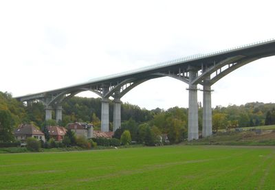
Lockwitztalbrücke, Girder bridge in Dresden, Germany.
The Lockwitztalbrücke extends across the Lockwitz Valley, connecting the towns of Kreischa and Dohna through a contemporary steel and concrete structure.
The construction and opening of the Lockwitztalbrücke in December 2005 marked a substantial advancement in regional transportation infrastructure for eastern Dresden.
The bridge serves as a central meeting point for regional outdoor activities, drawing local residents who participate in walking tours and cycling events.
Multiple transportation options, including buses and private vehicles, provide access to the bridge, with designated parking areas available near the structure.
The bridge design incorporates elevated pathways that offer direct views of the Lockwitz Valley while maintaining separate zones for vehicles and pedestrians.
Location: Dresden
Location: Kreischa
Location: Dohna
Inception: December 13, 2005
GPS coordinates: 50.97934,13.79469
Latest update: September 23, 2025 16:46
Wohnstallhaus, Scheune und Seitengebäude eines Dreiseithofes Am Rundling 16
1 km
Wohnstallhaus und Scheune eines Bauernhofes (Hakenhof) Am Rundling 14
1 km
Wohnstallhaus und Seitengebäude eines Bauernhofes Am Rundling 13
1.1 km
Kakaomühle Lockwitz
236 m
Wohnstallhaus eines Dreiseithofes, mit anbauten Burgstädtler Straße 49b
1 km
Wohnhaus und Seitengebäude eines Gehöftes Zur Linde 32
1 km
Wohnstallhaus, Scheune und Einfriedungsmauer eines Bauernhofes Am Rundling 2
765 m
Wohnhaus eines Zweiseithofes Am Rundling 1
784 m
Rittergut Borthen
796 m
Wohnstallhaus (mit zwei Hausnummern) eines ehemaligen Dreiseithofes, dazu Hofmauer mit Torbogen Dorfplatz 13; 13a
1.1 km
Schokoladenfabrik Rüger
786 m
Wohnstallhaus (Nr. 4) mit angebautem Seitengebäude (Nr. 4a) und Toranlage eines Zweiseithofes Am Rundling 4; 4a
796 m
Wohnhaus, Seitengebäude und Scheune eines Bauernhofes sowie Toranlage (Torpfeiler und Pforte) vom Dorfplatz und rückwärtiger Torbogen an der Scheune sowie Einfriedungsmauer des Gartens südwestlich hinter der Scheune Am Rundling 7
807 m
Wohnhaus (mit Schmiedewerkstatt) Burgstädtler Straße 38a
986 m
Wegestein Sobrigau
897 m
Einfriedungsmauer Nickerner Weg 6
858 m
Wohnstallhaus eines Bauernhofes sowie Hofmauer mit Torpfeilern und Pforte Am Rundling 17
1.1 km
Wohnstallhaus (ohne Anbauten) eines Bauernhofes sowie zwei Torpfeiler Am Rundling 1
1.1 km
Wohnstallhaus eines Bauernhofes Am Rundling 15
879 m
Altes Schloss, Neues Schloss, Wohn- und Wirtschaftsgebäude (Einzeldenkmale zu ID-Nr. 09302922) Kleinborthener Straße 4; 6; 10; 12
796 m
Gasthof Sobrigau mit Hauptgebäude, Rückgebäude und Seitengebäude Am Rundling 10; 10a
851 m
Wohnstallhaus, Scheune und Seitengebäude eines Dreiseithofes Dorfplatz 12
1.1 km
Wohnstallhaus eines Bauernhofes Am Rundling 8
827 m
Wohnhaus, Seitengebäude, Scheune und Toranlage eines Bauernhofes sowie Einfriedungsmauer des Gartens südwestlich hinter der Scheune Am Rundling 11
843 m
Scheune eines Zweiseithofes und Einfriedungsmauer des Gartens südwestlich hinter der Scheune Am Rundling 9
825 m
Wohnhaus und Toranlage (Torbogen und Pforte) eines Bauernhofes Am Rundling 6
808 m
Wohnhaus, Scheune und Toranlage eines Bauernhofes sowie Einfriedungsmauer des Gartens südwestlich hinter der Scheune Am Rundling 13
856 m
Einfriedungsmauer Am Rundling 5
830 mReviews
Visited this place? Tap the stars to rate it and share your experience / photos with the community! Try now! You can cancel it anytime.
Discover hidden gems everywhere you go!
From secret cafés to breathtaking viewpoints, skip the crowded tourist spots and find places that match your style. Our app makes it easy with voice search, smart filtering, route optimization, and insider tips from travelers worldwide. Download now for the complete mobile experience.
A unique approach to discovering new places❞
— Le Figaro
All the places worth exploring❞
— France Info
A tailor-made excursion in just a few clicks❞
— 20 Minutes