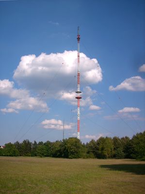
Sender Hoyerswerda/Zeißig, Communication tower in Hoyerswerda, Germany.
The steel lattice transmission tower rises above the Zeißig district, functioning as a central telecommunications facility for the Saxony region.
The tower was initially constructed for military communication purposes, later evolving into a civilian broadcasting structure serving the local population.
The transmission tower represents the technological advancement of Hoyerswerda, connecting inhabitants through radio and television broadcasts.
Located at coordinates 51.4211° N and 14.2838° E, the tower maintains strong signal coverage for radio and television transmission across surrounding areas.
The structure stands as the primary telecommunications hub in eastern Saxony, enabling continuous broadcast services throughout the surrounding territories.
Location: Hoyerswerda
GPS coordinates: 51.42110,14.28380
Latest update: March 6, 2025 04:10
Offene Tür – offenes Tor
2.3 km
Wald
2 km
LPG-Bauer
875 m
Planetarium Hoyerswerda
1.4 km
Vogelbaum
1.5 km
Wohnhaus, Auszugshaus und Scheune eines Dreiseithofes Dorfaue 30
895 m
Friedhofskapelle Spohla 129
1.8 km
Wohnblock (mit sechs Hausnummern) Hufelandstraße 36, 38, 40, 42, 44, 46 (Neustadt/WK 5)
2 km
Bauernhof mit Wohnhaus (mit Durchfahrt) und zwei Seitengebäuden (ein Bestandteil des Hofes auch die Scheune Nr. 31a, siehe dort) Dorfaue 31
890 m
Denkmal für die Gefallenen des Ersten und Zweiten Weltkrieges Dorfaue
787 m
Wandmosaik an der Lausitzhalle Hoyerswerda
2.3 km
Wohn-Hochhaus (mit vier Hausnummern) Bautzener Allee 45, 47, 49, 51 (Neustadt/WK 3)
2.3 km
Wohnhaus (mit Durchfahrt) und zwei Seitengebäude eines Bauernhofes Dorfaue 40
750 m
Zwei Seitengebäude (mit Oberlaube) und Scheune eines Bauernhofs Bautzener Straße 18
919 m
Wohnstallhaus und drei Seitengebäude Spohla 14
2.2 km
Sühnestein im Garten Bautzener Straße 20 (bei)
857 m
Abwasserpumpstation Franz-Liszt-Straße (Ecke Lilienthalstraße, Neustadt/WK 7)
1.8 km
Untermühle Spohla
2.2 km
Jugend
1.6 km
Mord- und Sühnekreuz Spohla 42 (neben)
2.2 km
Seitengebäude eines Bauernhofes Klein Zeißig 1
1.8 km
Versorgungszentrum, bestehend aus vier Gebäuden, gruppiert um einen Warenanlieferungshof Johann-Sebastian-Bach-Straße 11, 13, 15, 17 (Neustadt/WK 4)
2 km
Bauernhaus und Blockscheune eines Vierseithofes Spohla 44
2.1 km
POS „Hanns Eisler“ (ehemals); Schule Robert-Schumann-Straße 10 (Neustadt/WK 4)
2 km
Bauernhof mit Wohnhaus, Seitengebäude und Scheune sowie Hofmauer Dorfaue 11
572 m
Schrotholzscheune Dorfaue 36
850 m
Wohn-Hochhaus (mit vier Hausnummern) Bautzener Allee 53, 55, 57, 59 (Neustadt/WK 4)
2.2 km
Scheune eines Bauernhofes (ursprünglich Bestandteil des Bauernhofs Nr. 31, siehe dort) Dorfaue 31a
907 mReviews
Visited this place? Tap the stars to rate it and share your experience / photos with the community! Try now! You can cancel it anytime.
Discover hidden gems everywhere you go!
From secret cafés to breathtaking viewpoints, skip the crowded tourist spots and find places that match your style. Our app makes it easy with voice search, smart filtering, route optimization, and insider tips from travelers worldwide. Download now for the complete mobile experience.
A unique approach to discovering new places❞
— Le Figaro
All the places worth exploring❞
— France Info
A tailor-made excursion in just a few clicks❞
— 20 Minutes