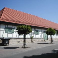
Synagogue Affaltrach, Jewish synagogue in Obersulm, Germany.
Synagogue Affaltrach is a religious building in Obersulm featuring neoromanesque architecture with symmetrically arranged windows along its sides and transverse facades. The structure displays the typical characteristics of a 19th century synagogue with clear, organized design elements.
The building was completed in 1851 with a donation from Nathan Krailsheimer and replaced an older structure that had closed in 1844. During the 1938 November pogroms, the exterior remained intact though the interior was damaged, and it later served as a warehouse and gymnasium.
The building carries the name of the community that built it and reflects through its architecture the religious importance it once held for the Jewish population of the region. Today visitors can discover the traces of this history and the memory of those communities within its walls.
The building now functions as a museum accessible to visitors who wish to explore its history, with guided tours available upon request. Planning ahead to check opening times and arrange a tour in advance is helpful for making the most of your visit.
The building survived the destruction of the November pogroms with its exterior intact, making it a rare example that physically withstood the horrors of that time. This resilience makes it an important place of remembrance and reflection today.
The community of curious travelers
AroundUs brings together thousands of curated places, local tips, and hidden gems, enriched daily by 60,000 contributors worldwide.