Enable Location

We need your location to show you interesting places around you

Discover nearby places

Find interesting locations and hidden gems around you

Precise directions

Get accurate directions and distances to places

Your location is never shared with other users. It's only used when you tap the location button.

Talsperre Döllnitzsee

Log in to your account

Start exploring — it's free

Trusted by 62,858 travelers worldwide

Continue with Google
Continue with Apple
or

We will send you a code to connect

By continuing, you accept our Terms and Conditions and our Privacy Policy

Check your inbox

We've sent a pincode in your inbox. Please enter the code below.

Talsperre Döllnitzsee

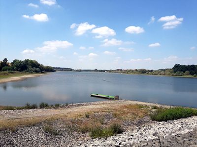
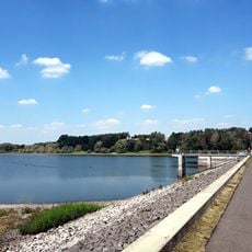
Talsperre Döllnitzsee, reservoir in Germany

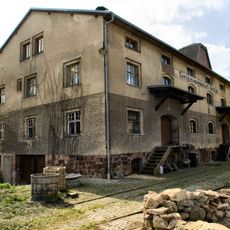
The Döllnitzsee reservoir is an earth dam in Wermsdorf, Saxony, that blocks the Döllnitz stream and forms several connected lakes. The water is surrounded by hiking trails, cycling paths and beaches, and provides space for boat rentals, fishing spots, and various water sports such as sailing and water skiing.

The dam was built in 1850 to store water and control flooding. Between 1981 and 1983, it underwent major repairs and reinforcement to ensure its safety and long-term function.

The name Döllnitzsee comes from the Döllnitz stream that feeds the reservoir. Today it serves as a recreation spot where visitors hike, fish, and boat while experiencing nature directly.

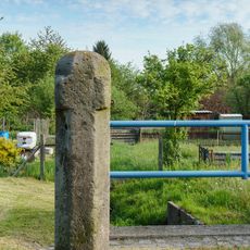
The lake is easily accessible with parking, bus stops, and on-site facilities such as restrooms and a snack bar. Visitors find a beach, playgrounds, and grilling areas, with dogs welcome and bicycle and boat rentals available.

The dam sits on a watershed where water flows toward either the Elbe or Mulde river depending on rainfall and current. This unusual geographic feature shows how natural water-path boundaries shape the region.

The community of curious travelers

AroundUs brings together thousands of curated places, local tips, and hidden gems, enriched daily by 60,000 contributors worldwide.

Start exploring
Location
GPS coordinates
51.26610,12.94170
Latest update
February 9, 2026 08:19
Around this place
Hubertusburg
Germany

Hubertusburg

1.3 km
Schlosskapelle Hubertusburg
Germany

Schlosskapelle Hubertusburg

1.3 km
Alte Poststation
Germany

Alte Poststation

1.9 km
Jagdschloss Wermsdorf
Germany

Jagdschloss Wermsdorf

1.8 km
Schule (mit nördlichem Anbau) und Einfriedung Döllnitzseeweg 3
Germany

Schule (mit nördlichem Anbau) und Einfriedung Döllnitzseeweg 3

923 m
Kirche Liptitz
Germany

Kirche Liptitz

943 m
Lime tree Göttwitz
Germany

Lime tree Göttwitz

1.9 km
Kirche Wermsdorf
Germany

Kirche Wermsdorf

1.8 km
Kgl.-sächs. Postmeilenstein Alte Poststation
Germany

Kgl.-sächs. Postmeilenstein Alte Poststation

1.9 km
Altes Wasserhaus
Germany

Altes Wasserhaus

1.9 km
Gasthof Zum Roten Ochsen
Germany

Gasthof Zum Roten Ochsen

1.9 km
Water dam of the Döllnitz reservoir
Germany

Water dam of the Döllnitz reservoir

688 m
Boundary stone Lindenstraße
Germany

Boundary stone Lindenstraße

2 km
Sachgesamtheit Schloss Hubertusburg mit folgenden Einzeldenkmalen: Schloss Hubertusburg (Nr. 1, Obj. 08970570), Bedienstetenwohnungen und Kasernen (Nr. 2-21a, Nr. 70a-76, Obj. 08974175), Schmiedetor (Nr. 8/9, Obj. 08974569), Pferdeschwemme (Nr. 11, O
Germany

Sachgesamtheit Schloss Hubertusburg mit folgenden Einzeldenkmalen: Schloss Hubertusburg (Nr. 1, Obj. 08970570), Bedienstetenwohnungen und Kasernen (Nr. 2-21a, Nr. 70a-76, Obj. 08974175), Schmiedetor (Nr. 8/9, Obj. 08974569), Pferdeschwemme (Nr. 11, O

986 m
Gedenkstein für Gefallene der Völkerschlacht Am Lindigt -
Germany

Gedenkstein für Gefallene der Völkerschlacht Am Lindigt -

1.9 km
Wohnhaus (ehemaliges Postgebäude bzw. Bankgebäude) in offener Bebauung, in Ecklage Wiesenweg Schloßstraße 2
Germany

Wohnhaus (ehemaliges Postgebäude bzw. Bankgebäude) in offener Bebauung, in Ecklage Wiesenweg Schloßstraße 2

1.7 km
Manor and Park Wiederoda
Germany

Manor and Park Wiederoda

2 km
Hubertusburg Castle horse pond
Germany

Hubertusburg Castle horse pond

1.3 km
Lime tree near hunting castle Wermsdorf
Germany

Lime tree near hunting castle Wermsdorf

1.8 km
Pfarrhaus Breite Straße 15
Germany

Pfarrhaus Breite Straße 15

926 m
Wasserturm Wermsdorf
Germany

Wasserturm Wermsdorf

1 km
Gasthof in offener Bebauung Hirschplatz 2
Germany

Gasthof in offener Bebauung Hirschplatz 2

1.9 km
Haltepunkt Mahlis (ehem.) Mahlis
Germany

Haltepunkt Mahlis (ehem.) Mahlis

1.9 km
Dorfgenossenschaft Mahlis Mahlis
Germany

Dorfgenossenschaft Mahlis Mahlis

1.7 km
Standbild Grimmaer Straße -
Germany

Standbild Grimmaer Straße -

1.4 km
Denkmal Clara-Zetkin-Straße -
Germany

Denkmal Clara-Zetkin-Straße -

1.8 km
Bahnhof Wermsdorf
Germany

Bahnhof Wermsdorf

1.3 km
Orgel der Katholische Hof- und Schlosskapelle im Schloss Hubertusburg
Germany

Orgel der Katholische Hof- und Schlosskapelle im Schloss Hubertusburg

1.3 km
Show the full map
« Talsperre Döllnitzsee - reservoir in Germany » is provided by Around Us (aroundus.com). Images and texts are derived from Wikimedia project under a Creative Commons license. You are allowed to copy, distribute, and modify copies of this page, under the conditions set by the license, as long as this note is clearly visible.

Discover hidden gems everywhere you go!

From secret cafés to breathtaking viewpoints, skip the crowded tourist spots and find places that match your style. Our app makes it easy with voice search, smart filtering, route optimization, and insider tips from travelers worldwide. Download now for the complete mobile experience.

Around Us App Screenshot

A unique approach to discovering new places

Le Figaro

All the places worth exploring

France Info

A tailor-made excursion in just a few clicks

20 Minutes

Around Us
Travel Guide & Maps
Download

Send to your phone

QR Code
1

Open the camera app on your mobile.

2

Point at the QR code with your camera. A notification will appear.

3

Tap the notification to open the link.