Talsperre Klingenberg

Log in to your account

AroundUs is a community-driven map of interesting places, built by curious explorers like you. It grows with every review, story, and photo you share.
Connect to save your favorite spots, contribute locations, and create personalized routes.
Continue with Google
Continue with Apple
Continue with X
Continue with Facebook
Continue with email
By continuing, you accept our Terms and Conditions and our Privacy Policy
Create an account
Add to collection
Map
Suggest a change
Share

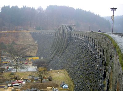
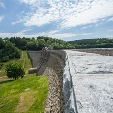
Talsperre Klingenberg, Reservoir and cultural heritage monument in Klingenberg, Germany.

Talsperre Klingenberg is a curved gravity dam made of rubble masonry that rises about 310 feet (94 meters) above the valley floor and is topped with a distinctive crown. The structure holds water for drinking supplies, manages flood control, and generates electricity through its power station.

Construction started in 1908 following severe flooding in 1897, driven by the need for flood protection, and the dam opened for operations in 1914. The project applied the latest engineering techniques of its era and shaped how water power was developed in the Saxon region.

The name comes from the Klingen Valley that the dam crosses, and over time it became an important landmark for the region. Visitors can still observe the classical architectural features that architect Hans Poelzig integrated into the design.

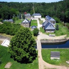
The reservoir is most accessible from viewpoints on the dam itself or along the shoreline paths that offer clear views of the structure. Wear sturdy shoes since ground conditions around the area vary depending on the season.

Between 2005 and 2013, the entire reservoir was drained for major renovation work, offering a rare chance to study the dam's internal structure closely. A temporary underground tunnel kept water flowing to Dresden during all those years.

Location: Klingenberg

Inception: 1908

Elevation above the sea: 394 m

Address: Beerwalde (Klingenberg)

Website: https://wasserwirtschaft.sachsen.de/TS_Klingenberg.html

GPS coordinates: 50.90000,13.54670

Latest update: December 8, 2025 19:44

Photos
Around this place
Streichholzbrücke
Germany

Streichholzbrücke

1.8 km
Wasserburg Ruppendorf
Germany

Wasserburg Ruppendorf

3.9 km
Protestant Church (Pretzschendorf)
Germany

Protestant Church (Pretzschendorf)

3.5 km
Wasserwerk Klingenberg
Germany

Wasserwerk Klingenberg

1.2 km
Dorfkirche Ruppendorf
Germany

Dorfkirche Ruppendorf

3.9 km
Tal der Wilden Weißeritz
Germany

Tal der Wilden Weißeritz

2.3 km
Dorfkirche Pretzschendorf, einschl. Kirchhof, Kriegerdenkmal Zur Kirche 12a
Germany

Dorfkirche Pretzschendorf, einschl. Kirchhof, Kriegerdenkmal Zur Kirche 12a

3.5 km
Hosenmühle
Germany

Hosenmühle

2.7 km
Sandstein-Bogenbrücke Beerwalder Straße 4
Germany

Sandstein-Bogenbrücke Beerwalder Straße 4

3.9 km
Sachgesamtheitsbestandteil der Sachgesamtheit Talsperre Klingenberg für den Teilabschnitt OT Klingenberg und OT Pretzschendorf: die Wasserfläche des Talsperrenbeckens, als Teil der Sachgesamtheit ID-Nr. 09304131 - -
Germany

Sachgesamtheitsbestandteil der Sachgesamtheit Talsperre Klingenberg für den Teilabschnitt OT Klingenberg und OT Pretzschendorf: die Wasserfläche des Talsperrenbeckens, als Teil der Sachgesamtheit ID-Nr. 09304131 - -

1.6 km
Church in Colmnitz (Klingenberg)
Germany

Church in Colmnitz (Klingenberg)

3.8 km
Barthmühle
Germany

Barthmühle

3.8 km
Talsperre Klingenberg (Sachgesamtheit) Klingenberg
Germany

Talsperre Klingenberg (Sachgesamtheit) Klingenberg

1 km
Vordermühle Klingenberg
Germany

Vordermühle Klingenberg

2 km
Schule in historistischen Formen Dorfstraße 9b
Germany

Schule in historistischen Formen Dorfstraße 9b

1.9 km
Protestant Church
Germany

Protestant Church

2.1 km
Rittergut Colmnitz
Germany

Rittergut Colmnitz

3.7 km
Sachgesamtheit '''Rittergut Colmnitz''' mit den Einzeldenkmalen: Herrenhaus, Wohnhaus, Scheune Am Dorfplatz 3; 3a
Germany

Sachgesamtheit '''Rittergut Colmnitz''' mit den Einzeldenkmalen: Herrenhaus, Wohnhaus, Scheune Am Dorfplatz 3; 3a

3.7 km
Station 78 Klingenberg
Germany

Station 78 Klingenberg

2.4 km
Rittergut Klingenberg
Germany

Rittergut Klingenberg

1.9 km
Oberer St.-Michaelis-Stolln und Thelersäule Höckendorf
Germany

Oberer St.-Michaelis-Stolln und Thelersäule Höckendorf

3.2 km
Hintermühle Klingenberg
Germany

Hintermühle Klingenberg

1.6 km
Wohnmühlenhaus
Germany

Wohnmühlenhaus

2.7 km
Winkelmühle Dorfhain
Germany

Winkelmühle Dorfhain

2.6 km
Stübemühle
Germany

Stübemühle

3.3 km
Rittergut Pretzschendorf, Wohnhaus Schulgasse 1
Germany

Rittergut Pretzschendorf, Wohnhaus Schulgasse 1

3.2 km
Kriegerdenkmal Erster Weltkrieg, um zwei Gedenksteine Zweiter Weltkrieg ergänzt Mühlenstraße 53 (vor)
Germany

Kriegerdenkmal Erster Weltkrieg, um zwei Gedenksteine Zweiter Weltkrieg ergänzt Mühlenstraße 53 (vor)

3 km
Haltepunkt Niederpretzschendorf
Germany

Haltepunkt Niederpretzschendorf

2.9 km
Show the full map
Reviews

Visited this place? Tap the stars to rate it and share your experience / photos with the community! Try now! You can cancel it anytime.

« Talsperre Klingenberg - Reservoir and cultural heritage monument in Klingenberg, Germany » is provided by Around Us (aroundus.com). Images and texts are derived from Wikimedia project under a Creative Commons license. You are allowed to copy, distribute, and modify copies of this page, under the conditions set by the license, as long as this note is clearly visible.

Discover hidden gems everywhere you go!

From secret cafés to breathtaking viewpoints, skip the crowded tourist spots and find places that match your style. Our app makes it easy with voice search, smart filtering, route optimization, and insider tips from travelers worldwide. Download now for the complete mobile experience.

Around Us App Screenshot

A unique approach to discovering new places

Le Figaro

All the places worth exploring

France Info

A tailor-made excursion in just a few clicks

20 Minutes