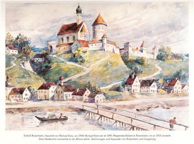
Burg Rosenheim, Medieval castle ruins in Stephanskirchen, Germany
Burg Rosenheim is the ruins of a medieval castle perched on a hill at about 460 meters (1,500 feet) above sea level overlooking the Inn River in Upper Bavaria. The remains show the platform and moat of the former stronghold, with foundations of a defensive tower and later Gothic additions still visible in the stonework.
The castle was built after 1150 under the Counts of Wasserburg, a dominant family in the region at that time. It suffered severe damage in 1425 during the Bavarian succession disputes, and the fortress never fully recovered from those conflicts.
The name recalls the medieval Rosenheim family who shaped this place in earlier centuries. Visitors today can read from the shape of the ruins how a compact fortified tower and later Gothic additions were combined into a single structure.
The site is reachable by following marked hiking trails to Schlossberg, from where you can explore the ruins on foot. It is best to visit during daylight hours and wear sturdy footwear, as the ground is uneven with varying elevations.
The location on the eastern bank of the Inn was strategically so valuable that the castle served as a control point for medieval trade routes crossing Bavaria. This position allowed residents to monitor all river traffic and the main trade roads moving through the region.
The community of curious travelers
AroundUs brings together thousands of curated places, local tips, and hidden gems, enriched daily by 60,000 contributors worldwide.