Teufelsstein, Archaeological site in Haardt, Germany
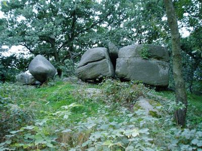
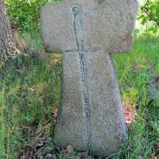
The Teufelsstein is a natural rock formation on a 317-meter hill with five carved steps leading to a hollowed surface at its summit. The top offers views of the Palatinate Forest and Rhine Plain.
The site served as a Celtic gathering place for rituals in ancient times and was later used by various cultures. The steps and symbols were likely carved over many generations by different peoples.
The stone displays carved symbols such as sun wheels and runes left by different visitors across centuries. These marks show how various people considered this location important over long periods of time.
To reach the stone, you need to walk uphill as the old cable car is no longer operating. The path is well accessible, and the climb provides gradually improving views of the surrounding landscape.
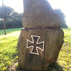
The name comes from a medieval story where monks claimed they persuaded the Devil himself to help with construction. This legend shows how the location has captured local imagination for centuries.
GPS coordinates: 51.21920,14.52179
Latest update: December 14, 2025 15:02
Blücherstein Kreckwitz
1.8 km
Kirche Kleinbautzen
825 m
Kirche Purschwitz
1.8 km
Purschwitz/Poršicy 36
1.6 km
Denkmal für die Gefallenen des Ersten Weltkrieges Purschwitz
1.7 km
Kriegerdenkmal Kleinbautzen
836 m
Ehemalige Kirchschule und winkliges Wohnhaus Purschwitz 11
1.8 km
Rittergut Kleinbautzen
1.2 km
Wegestein (etwa 300 m nördlich des nördlichen Ortsausgangs)
2 km
Steinbogenbrücke über den Mühlgraben Pließkowitzer Dorfstraße
1.6 km
Purschwitz/Poršicy rectory
1.8 km
Denkmal für die Schlacht bei Bautzen, mit Einfriedung Purschwitz 9
1.8 km
Purschwitz 40
1.6 km
Granitportal Purschwitz 55
1.7 km
Wohnhaus mit geschlossener Oberlaube und Seitengebäude eines Dreiseithofes Purschwitz 31
1.7 km
Häuslerhaus und Scheune Purschwitz 12
1.8 km
Schloss und Gartenpavillon (Nr. 12) mit umgebendem Gartenbereich, Wirtschaftsgebäude und winklige Scheune (Nr. 11) sowie nördliche Einfriedungsmauer des ehemaligen Rittergutes Alte Dorfstraße 11, 12
1.7 km
Mord- und Sühnekreuz (etwa 300 m nördlich des nördlichen Ortsausgangs)
2 km
Kirche und Kirchhof Purschwitz (Sachgesamtheit) Purschwitz 10
1.9 km
Purschwitz/Poršicy 39
1.6 km
Herrenhaus Purschwitz, ohne Anbau (Einzeldenkmal zu ID-Nr. 09300639) Purschwitz 3
1.8 km
Granitportal des Gasthofs Purschwitzer Straße 17
885 m
Wegestein Niederguriger Straße 26 (bei)
2 km
Rittergut und Gutspark Purschwitz (Sachgesamtheit) Purschwitz 3, 4, 5a, 5b, 5c, 6, 7, 8, 9
1.8 km
Kleinbautzen, Mord- und Sühnekreuz
852 m
Kleinbautzen, Wegestein
836 m
Kirche (mit Ausstattung), Kirchhof mit Einfriedung sowie Eingangstor, auf dem Kirchhof Denkmal für die Gefallenen des Ersten Weltkrieges sowie vier Grabmale Purschwitzer Straße
823 m
Ehemaliges Wohnstallhaus eines Gehöftes Niederguriger Straße 26
2 kmVisited this place? Tap the stars to rate it and share your experience / photos with the community! Try now! You can cancel it anytime.
Discover hidden gems everywhere you go!
From secret cafés to breathtaking viewpoints, skip the crowded tourist spots and find places that match your style. Our app makes it easy with voice search, smart filtering, route optimization, and insider tips from travelers worldwide. Download now for the complete mobile experience.
A unique approach to discovering new places❞
— Le Figaro
All the places worth exploring❞
— France Info
A tailor-made excursion in just a few clicks❞
— 20 Minutes