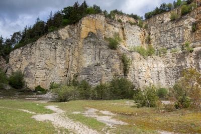
Steinbruch bei Kottingwörth, Historical quarry in Beilngries, Germany.
The Steinbruch bei Kottingwörth is a former limestone quarry with dimensions of roughly 200 meters and rock walls rising to about 70 meters high. The pit displays multiple stone layers that reveal the geological history of this landscape.
The quarry developed through systematic limestone extraction that ran from 1938 to 1975, supplying material for road construction projects. After extraction ended, the site became recognized as a significant geological location and gained protection as one of Bavaria's important geotopes.
The site draws hikers and geology enthusiasts who come to observe the exposed rock walls and learn about local mineral formations. It reflects how communities have traditionally worked with the region's natural resources across many generations.
The site is accessible via marked hiking trails from Kottingwörth, Beilngries, or Töging, with parking areas nearby for easy arrival. Exploring on foot works best to view the rock formations from different angles and distances.
The rock walls contain hundreds of limestone layers documenting over 5 million years of marine development from the Upper Jurassic period. These visible strata allow visitors to see deep time and understand how ancient seas shaped the region's geology.
The community of curious travelers
AroundUs brings together thousands of curated places, local tips, and hidden gems, enriched daily by 60,000 contributors worldwide.