Chest opened
+${chestReward.xp} XP
Explorer
NOUVEAU ×${chestReward.collectible.quantity}
tapez pour fermer

See the monuments around you in AR Open chests in the app

Around Us is built for your phone — point your camera at the streets and discover the monuments and places around you in augmented reality. Around Us is built for your phone — chests unlock when you walk, explore and capture nearby places.

Enable Location

We need your location to show you interesting places around you

Discover nearby places

Find interesting locations and hidden gems around you

Precise directions

Get accurate directions and distances to places

Your location is never shared with other users. It's only used when you tap the location button.

Log in to your account

Start exploring — it's free

Trusted by 83,985 travelers worldwide

Continue with Google
Continue with Apple
or

We will send you a code to connect

By continuing, you accept our Terms and Conditions and our Privacy Policy

Check your inbox

We've sent a pincode in your inbox. Please enter the code below.

Achsel-Berg
Discussion Reviews Photo
8.8k Popularity

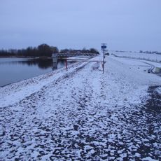
Achsel-Berg, Summit in Saxony, Germany.

Achsel-Berg is a hill in the Saxon landscape with marked walking paths that wind through its terrain. The routes connect various viewpoints and pass through areas of trees and open ground.

The hill has been used by people over centuries and shows traces of earlier settlement in the area. The region developed as an important place in the Saxon landscape.

The hill is popular with local walkers and serves as a place for exercise and outdoor time throughout the year. The well-used paths show how much the area matters to people who live nearby.

The hill is accessible on foot and offers several starting points for walkers. Signs along the routes help with finding your way.

From the top, visitors can watch different bird species and small forest animals in their natural home. It is a good spot to see local wildlife going about their day.

The community of curious travelers

AroundUs brings together thousands of curated places, local tips, and hidden gems, enriched daily by 60,000 contributors worldwide.

Start exploring
Location
GPS coordinates
51.25551,13.60283
Latest update
July 27, 2026 19:48
Around this place
Talsperre Nauleis
Germany

Talsperre Nauleis

880 m
Germany

Talsperrenwiese Reinersdorf

666 m
Germany

Wegestein

1 km
Germany

Kirche , Kirchhof mit Einfriedung und Denkmal für die Gefallenen des Ersten Weltkrieges Kleine Seite -

1.1 km
Germany

Wohnhaus , Seitengebäude , Scheune sowie drei Torpfeiler eines Dreiseithofes Am Anger 6; 7

1.1 km
Germany

Transformatorenhäuschen Reinersdorf

1 km
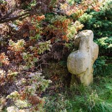
Steinkreuz Nauleis
Germany

Steinkreuz Nauleis

1.6 km
Germany

Transformatorenhäuschen Nauleis

1.6 km
Germany

Wegestein

1.7 km
Germany

Wohnstallhaus eines Dreiseithofes und drei Torpfeiler Am Anger 25

1 km
Germany

Wohnhaus (Nr. 10a), Seitengebäude (Nr. 10) und Scheune sowie Einfriedung (mit Torbogen) und Toreinfahrt eines Bauernhofes Am Rundling 10; 10a

1.6 km
Germany

Steinkreuz Reinersdorf

1.1 km
Germany

Wohnstallhaus (Nr. 15, an Rückseite angebautes Backhaus), Seitengebäude (Nr. 15a) und Scheune sowie Toranlage eines Dreiseithofes Am Rundling 15; 15a

1.6 km
Germany

Denkmal für die Gefallenen des Ersten Weltkrieges Am Rundling -

1.6 km
Germany

Wohnhaus eines Bauernhofes Am Anger 22

1 km
Germany

Seitengebäude (Wohnstallhaus) eines Dreiseithofes Am Anger 24

1 km
Germany

Wohnstallhaus und Seitengebäude eines Dreiseithofes sowie Toreinfahrt (mit Pforte) zum Hof Kleine Seite 19

1.1 km
Germany

Pfarrhaus Kleine Seite 17

1.1 km
Germany

Wohnhaus (ohne Anbau) und Seitengebäude (Ausgedingehaus) eines Bauernhofes sowie seitliche Einfriedung Kleine Seite 14

1.1 km
Germany

Seitengebäude (Wohnstallhaus) eines Dreiseithofes Am Anger 26

1 km
Germany

Wohnstallhaus eines Dreiseithofes Am Rundling 12

1.7 km
Germany

Seitengebäude (Wohnstallhaus mit Kumthalle) und daran angebautes Stallgebäude eines Vierseithofes Kleine Seite 18

1.1 km
Germany

Wohnstallhaus, Seitengebäude (ohne überformten Kopfbau, Nr. 17) und Scheune eines Dreiseithofes, sowie Stützmauern mit eingezäunten Vorgärten, Einfriedungsmauern hinter der Scheune und drei Torpfeiler zum Hof Am Anger 18

948 m
Germany

Gasthof, mit Einfriedungsmauer Am Anger 14

1 km
Germany

Seitengebäude (Wohnstallhaus) eines Dreiseithofes Am Anger 9

1 km
Germany

Seitengebäude (Wohnstallhaus) und Einfriedungsmauer eines Dreiseithofes Am Anger 4

1.1 km
Germany

Einfriedungsmauern von Gartengrundstücken Am Anger -

1.1 km
Germany

Stieleiche in den Hopfenbachwiesen Nauleis

1.6 km
Show the full map
Reviews
Share your experience

No review yet

Discussions
Start a discussion...

No discussion yet

« Achsel-Berg - Summit in Saxony, Germany » is provided by Around Us (aroundus.com). Images and texts are derived from Wikimedia project under a Creative Commons license. You are allowed to copy, distribute, and modify copies of this page, under the conditions set by the license, as long as this note is clearly visible.

Discover hidden gems everywhere you go!

From secret cafés to breathtaking viewpoints, skip the crowded tourist spots and find places that match your style. Our app makes it easy with voice search, smart filtering, route optimization, and insider tips from travelers worldwide. Download now for the complete mobile experience.

Around Us App Screenshot

A unique approach to discovering new places

Le Figaro

All the places worth exploring

France Info

A tailor-made excursion in just a few clicks

20 Minutes

Around Us
Travel Guide & Maps
Download

Send to your phone

QR Code
1

Open the camera app on your mobile.

2

Point at the QR code with your camera. A notification will appear.

3

Tap the notification to open the link.