
Stallstadel, aichlberg; östlich angebauter Satteldachbau mit Bundwerkobergeschoss, 2. Viertel 19. Jahrhundert
Location: Burgkirchen an der Alz
Address: Aichlberg 6
GPS coordinates: 48.10587,12.72581
Latest update: November 14, 2025 14:07
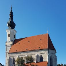
Mariä Himmelfahrt
825 m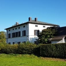
Pfarrhaus Asten
854 m
Wegkapelle
354 m
Scheune Am Herrnsitz 1 in Tittmoning
1.1 km
Cultural heritage D-1-7942-0179 in Tittmoning
818 m
Krötzing, Brunner Feld, Tittmoning
1.1 km
Sogenanntes Pestkreuz
844 m
Kriegerdenkmal Dorfstraße 11 in Tittmoning
830 m
Friedhofsmauer Dorfstraße 11 in Tittmoning
816 m
Stadel
77 m
Stallstadel Am Herrnsitz 1 in Tittmoning
1.1 km
Dreiseithof
1.1 km
Wayside cross
1.2 km
Wayside cross
850 m
Wayside shrine
1 km
Wayside shrine
674 m
Wayside cross
624 m
Wayside cross
531 m
Wayside cross
723 mReviews
Visited this place? Tap the stars to rate it and share your experience / photos with the community! Try now! You can cancel it anytime.
Discover hidden gems everywhere you go!
From secret cafés to breathtaking viewpoints, skip the crowded tourist spots and find places that match your style. Our app makes it easy with voice search, smart filtering, route optimization, and insider tips from travelers worldwide. Download now for the complete mobile experience.

A unique approach to discovering new places❞
— Le Figaro
All the places worth exploring❞
— France Info
A tailor-made excursion in just a few clicks❞
— 20 Minutes