, bildstock, 19. Jahrhundert; zu Niederham, Haus Nr. 1 gehörig
Location: Tittmoning
Address: Niederham 1
GPS coordinates: 48.10402,12.72867
Latest update: November 8, 2025 20:49
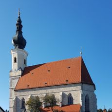
Mariä Himmelfahrt
675 m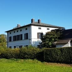
Pfarrhaus Asten
684 m
Wegkapelle
632 m
Cultural heritage D-1-7942-0179 in Tittmoning
669 m
Scheune Am Herrnsitz 1 in Tittmoning
937 m
Krötzing, Brunner Feld, Tittmoning
1.1 km
Friedhofsmauer Dorfstraße 11 in Tittmoning
666 m
Sogenanntes Pestkreuz
860 m
Kriegerdenkmal Dorfstraße 11 in Tittmoning
686 m
Stadel
324 m
Stallstadel
296 m
Stallstadel Am Herrnsitz 1 in Tittmoning
939 m
Dreiseithof
924 m
Wayside cross
1 km
Wayside cross
867 m
Wayside shrine
1.1 km
Wayside shrine
694 m
Wayside shrine, Christianity
598 m
Wayside cross
813 m
Wayside cross
1 kmReviews
Visited this place? Tap the stars to rate it and share your experience / photos with the community! Try now! You can cancel it anytime.
Discover hidden gems everywhere you go!
From secret cafés to breathtaking viewpoints, skip the crowded tourist spots and find places that match your style. Our app makes it easy with voice search, smart filtering, route optimization, and insider tips from travelers worldwide. Download now for the complete mobile experience.

A unique approach to discovering new places❞
— Le Figaro
All the places worth exploring❞
— France Info
A tailor-made excursion in just a few clicks❞
— 20 Minutes