
Bundwerkstadel, satteldachbau, Anfang 19. Jahrhundert
Location: Bodenkirchen
Address: Niederaicher Straße 52
GPS coordinates: 48.42955,12.41992
Latest update: November 21, 2025 22:16
St. Ulrich
969 m
St. Johann Baptist
1.2 km
Cultural heritage D-2-7540-0004 in Bodenkirchen
285 m
Cultural heritage D-2-7540-0172 in Bodenkirchen
1.2 km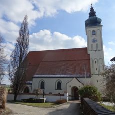
Katholische Pfarrkirche Ulrich von Augsburg
969 m
Cultural heritage D-2-7540-0175 in Bodenkirchen
1.2 km
Pfarrhof Bergstraße 4 in Bodenkirchen
1.2 km
Pfarrhof mit Getreidekasten
1.1 km
Cultural heritage D-2-7540-0173 in Bodenkirchen
970 m
Stallstadel Niederaicher Straße 42 in Bodenkirchen
312 m
Wohnhaus
1.2 km
Zugehöriger Getreidekasten
430 m
Scheune Falkensteinweg 1 in Bodenkirchen
222 m
Kornspeicher Bergstraße 4 in Bodenkirchen
1.1 km
Pfarrhaus
1 km
Hakenhof
331 m
Kriegerdenkmal für die Gefallenen des Erster Weltkrieg und Zweiter Weltkrieg
1.2 km
Cultural heritage D-2-7540-0176 in Bodenkirchen
1.1 km
Wohnstallhaus mit Stadel
240 m
Zwei Blockbau-Traidkästen
1.2 km
Wohnstallhaus eines Vierseithofs mit Stadel
54 m
Stadel
1.2 km
Scheune Niederaicher Straße 50 in Bodenkirchen
53 m
Kornspeicher Niederaicher Straße 50 in Bodenkirchen
35 m
Wayside cross
1.2 km
Wayside cross
919 m
Wayside cross
831 m
Memorial, war memorial
1.2 kmReviews
Visited this place? Tap the stars to rate it and share your experience / photos with the community! Try now! You can cancel it anytime.
Discover hidden gems everywhere you go!
From secret cafés to breathtaking viewpoints, skip the crowded tourist spots and find places that match your style. Our app makes it easy with voice search, smart filtering, route optimization, and insider tips from travelers worldwide. Download now for the complete mobile experience.

A unique approach to discovering new places❞
— Le Figaro
All the places worth exploring❞
— France Info
A tailor-made excursion in just a few clicks❞
— 20 Minutes