
Pestsäule, bildstock, hoher Rotmarmorschaft mit Laterne, Anfang 16. Jahrhundert; 1971 in die Ortsmitte versetzt
Location: Vachendorf
Address: Zwischen Hauptstraße und Grabenstätter Straße
GPS coordinates: 47.84267,12.60698
Latest update: November 21, 2025 08:58
Cultural heritage D-1-8141-0122 in Vachendorf
403 m
Schmiede
630 m
Cultural heritage D-1-8141-0100 in Vachendorf
1.2 km
Bauernhaus
144 m
Cultural heritage D-1-8141-0088 in Vachendorf
736 m
Cultural heritage D-1-8141-0084 in Vachendorf
84 m
Pestsäule
1.1 km
Cultural heritage D-1-8141-0085 in Vachendorf
393 m
Bauernhaus
1.4 km
Bauernhaus
1.4 km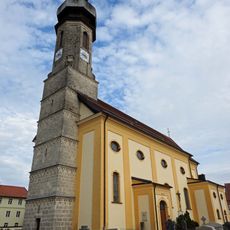
Mariä Himmelfahrt
80 m
Katholischer Pfarrhof
93 m
Ehemaliges Bauernhaus
23 m
Bildstock
477 m
Bauernhaus
1.2 km
Ehemaliges Bauernhaus
637 m
St. Georg am Berg
735 m
Getreidekasten
184 m
Bauernhaus
135 m
Wayside cross
1.3 km
Wayside cross
935 m
Aufleger-Kreuz
942 m
Wayside cross, Christianity
83 m
Christianity, wayside cross
856 m
Jubiläumsstein
888 m
Wayside cross
643 mReviews
Visited this place? Tap the stars to rate it and share your experience / photos with the community! Try now! You can cancel it anytime.
Discover hidden gems everywhere you go!
From secret cafés to breathtaking viewpoints, skip the crowded tourist spots and find places that match your style. Our app makes it easy with voice search, smart filtering, route optimization, and insider tips from travelers worldwide. Download now for the complete mobile experience.

A unique approach to discovering new places❞
— Le Figaro
All the places worth exploring❞
— France Info
A tailor-made excursion in just a few clicks❞
— 20 Minutes