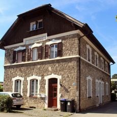
, bundwerkstadel (Südflügel des Vierseithofes), erbaut 1837 (bezeichnet mit dem Jahr), hierher versetzt 1857, erweitert 1913; zugehörig eingeschossiger Getreidekasten, bezeichnet mit dem Jahr 1746, nördlich des Hofes frei aufgestellt
Location: Tittmoning
Address: Allmoning 4
GPS coordinates: 48.04969,12.76557
Latest update: November 20, 2025 03:32
Bahnhof Tittmoning
1.1 km
St. Michael (Tittmoning)
1.2 km
Friedhof Traunsteiner Straße 2 in Tittmoning
1.1 km
Friedhof Traunsteiner Straße 1 in Tittmoning
1.1 km
Friedhof Traunsteiner Straße 1 in Tittmoning
1.2 km
Friedhof Traunsteiner Straße 2 in Tittmoning
1.2 km
Laufener Straße 22
919 m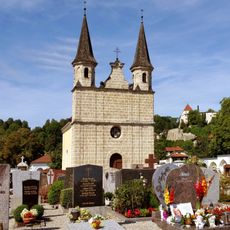
Friedhofskapelle
1.2 km
Cultural heritage D-1-7942-0109 in Tittmoning
880 m
Kornspeicher Allmoning 4 in Tittmoning
64 m
Mühlgebäude
1.2 km
Cultural heritage D-1-7942-0090 in Tittmoning
779 m
Schlosskapelle Burg 8 in Tittmoning
1.2 km
Sommerhaus des ehemaligen Augustiner-Eremitenklosters
1.2 km
Ringmauer Burg 3; Burg 4; Burg 6 in Tittmoning
1.2 km
Mauer Burg 9 in Tittmoning
1.2 km
Burg Burg 7 in Tittmoning
1.2 km
Wohnhaus Burg 6 in Tittmoning
1.2 km
Hofkapelle
548 m
Scenic viewpoint
1.1 km
Wayside cross
1.1 kmReviews
Visited this place? Tap the stars to rate it and share your experience / photos with the community! Try now! You can cancel it anytime.
Discover hidden gems everywhere you go!
From secret cafés to breathtaking viewpoints, skip the crowded tourist spots and find places that match your style. Our app makes it easy with voice search, smart filtering, route optimization, and insider tips from travelers worldwide. Download now for the complete mobile experience.

A unique approach to discovering new places❞
— Le Figaro
All the places worth exploring❞
— France Info
A tailor-made excursion in just a few clicks❞
— 20 Minutes