Stadel, schollaberg; mit Bundwerk, Ende 19. Jahrhundert
Location: Pleiskirchen
Address: Schollaberg 4
GPS coordinates: 48.30780,12.68205
Latest update: November 19, 2025 01:45

Katholische Filialkirche St. Stephan
1.4 km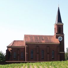
Katholische Pfarrkirche Maria Hilf
1.8 km
Hofkapelle
1.8 km
Kapelle St. Wolfgang, sog. Gallerkapelle
1.2 km
Stadel
49 m
Cultural heritage D-1-7642-0022 in Reischach
1.4 km
Stadel
1.8 km
Stadel
998 m
Wohnstallhaus
1 km
Ehemaliges Kleinbauernhaus
1.9 km
Scheune Rockersbach 43 in Reischach
1.4 km
Nebengebäude Harpeting 2 in Pleiskirchen
1 km
Bauernhaus
1.6 km
Ehemaliges Kleinbauernhaus
1.8 km
Wohnstallhaus
1.3 km
Bundwerkstadel
807 m
Scheune Harpeting 2 in Pleiskirchen
997 m
Stadel Heitzmannsberg 40 in Reischach
998 m
Friedhofsmauer Nähe Schuttgrube; Wald b.Winhöring 9 in Pleiskirchen
1.8 km
Wohnstallhaus Rockersbach 43 in Reischach
1.3 km
Scenic viewpoint
934 m
Wayside cross
1.5 km
Wayside cross
1.8 km
Wayside cross
1.4 km
Wayside cross
1.1 km
Wayside cross
1 km
Wayside cross
1.8 km
Wayside shrine
1.1 kmReviews
Visited this place? Tap the stars to rate it and share your experience / photos with the community! Try now! You can cancel it anytime.
Discover hidden gems everywhere you go!
From secret cafés to breathtaking viewpoints, skip the crowded tourist spots and find places that match your style. Our app makes it easy with voice search, smart filtering, route optimization, and insider tips from travelers worldwide. Download now for the complete mobile experience.

A unique approach to discovering new places❞
— Le Figaro
All the places worth exploring❞
— France Info
A tailor-made excursion in just a few clicks❞
— 20 Minutes