
Stadel mit Gitterbundwerk
Stadel mit Gitterbundwerk, Hub; Südflügel des ehemaligen Vierseithofes, bezeichnet mit dem Jahr 1845
Location: Garching an der Alz
Address: Hub 66
GPS coordinates: 48.15312,12.58919
Latest update: November 9, 2025 12:30
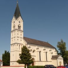
St. Nikolaus
2 km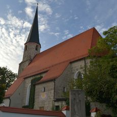
Katholische Filialkirche St. Stephan
1.8 km
Kapelle
2 km
Vierzehn-Nothelfer-Kapelle oder Berndl-Kapelle
2 km
Kapelle
772 m
Cultural heritage D-1-7841-0184 in Garching an der Alz
1.8 km
Bildstock
1.1 km
Ehemaliges Bauernhaus des Vierseithofes
2 km
Cultural heritage D-1-7841-0021 in Garching an der Alz
1.8 km
Cultural heritage D-1-7841-0060 in Unterneukirchen
1.8 km
Steinkreuz
1.3 km
Stadel
842 m
Stadel
667 m
Kornspeicher Langschwert 70 in Garching an der Alz
1.4 km
Vierseithof
1.7 km
Scheune Simetsbichl 64 in Garching an der Alz
658 m
Scheune Mauerberg 46 in Garching an der Alz
1.7 km
Vorderkammerhub
1.9 km
Ehemaliges Pfarrhaus
2 km
Hütte
1.4 km
Nebengebäude Mauerberg 46 in Garching an der Alz
1.7 km
Cultural heritage D-1-7841-0202 in Garching an der Alz
2 km
Scheune Kammerhub 2 in Unterneukirchen
2 km
Nebengebäude Kammerhub 2 in Unterneukirchen
2 km
Wayside cross
1.6 km
Wayside shrine
1.4 km
Christianity, wayside shrine
2 km
Wayside cross
1.8 kmReviews
Visited this place? Tap the stars to rate it and share your experience / photos with the community! Try now! You can cancel it anytime.
Discover hidden gems everywhere you go!
From secret cafés to breathtaking viewpoints, skip the crowded tourist spots and find places that match your style. Our app makes it easy with voice search, smart filtering, route optimization, and insider tips from travelers worldwide. Download now for the complete mobile experience.

A unique approach to discovering new places❞
— Le Figaro
All the places worth exploring❞
— France Info
A tailor-made excursion in just a few clicks❞
— 20 Minutes