
Bildstock, balghub; Wohl erste Hälfte 17. Jahrhundert; westlich am Wegkreuz
Location: Unterneukirchen
Address: Balghub 1
GPS coordinates: 48.16207,12.59404
Latest update: November 11, 2025 17:05
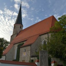
Katholische Filialkirche St. Stephan
1.5 km
Kapelle
312 m
Ehemaliges Bauernhaus des Vierseithofes
964 m
Bauernhaus Hager 1 in Unterneukirchen
1.7 km
Ehemaliges Kleinbauernhaus, sog. Ammerl-Hof
1.7 km
Cultural heritage D-1-7841-0184 in Garching an der Alz
1.5 km
Stadel mit Gitterbundwerk
1.1 km
Bauernhaus
1.7 km
Ehemaliges Kleinbauernhaus
1.4 km
Stadel
1.6 km
Bauernhaus Birner 1 in Unterneukirchen
1.5 km
Stadel
852 m
Cultural heritage D-1-7841-0060 in Unterneukirchen
905 m
Steinkreuz
350 m
Scheune Hager 1 in Unterneukirchen
1.7 km
Scheune Simetsbichl 64 in Garching an der Alz
1.5 km
Vierseithof
1.5 km
Cultural heritage D-1-7841-0175 in Unterneukirchen
1.9 km
Nebengebäude Mauerberg 46 in Garching an der Alz
1.5 km
Scheune Mauerberg 46 in Garching an der Alz
1.5 km
Scheune Kammerhub 2 in Unterneukirchen
945 m
Nebengebäude Kammerhub 2 in Unterneukirchen
948 m
Vorderkammerhub
892 m
Bauernhaus
1.5 km
Wayside cross
1.1 km
Wayside cross
1.5 km
Wayside cross
1.7 km
Wayside cross
1.4 kmReviews
Visited this place? Tap the stars to rate it and share your experience / photos with the community! Try now! You can cancel it anytime.
Discover hidden gems everywhere you go!
From secret cafés to breathtaking viewpoints, skip the crowded tourist spots and find places that match your style. Our app makes it easy with voice search, smart filtering, route optimization, and insider tips from travelers worldwide. Download now for the complete mobile experience.

A unique approach to discovering new places❞
— Le Figaro
All the places worth exploring❞
— France Info
A tailor-made excursion in just a few clicks❞
— 20 Minutes