Ehemaliges Kleinbauernhaus, building in Unterneukirchen, Upper Bavaria, Germany
Location: Unterneukirchen
Address: Brandstätt 2
GPS coordinates: 48.16679,12.61169
Latest update: November 21, 2025 11:32
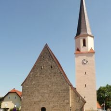
St. Johannes Evangelist und Ägidius
582 m
Kapelle
1.6 km
Ehemaliges Bauernhaus des Vierseithofes
757 m
Ehemaliges Kleinbauernhaus, sog. Ammerl-Hof
368 m
Bauernhaus Hager 1 in Unterneukirchen
1.7 km
Bildstock
1.4 km
Bauernhaus Birner 1 in Unterneukirchen
1.3 km
Cultural heritage D-1-7841-0060 in Unterneukirchen
519 m
Bauernhaus
1.6 km
Bundwerkstadel
1.9 km
Stadel
1.5 km
Steinkreuz
1.5 km
Scheune Hager 1 in Unterneukirchen
1.6 km
Bundwerkstadel
1.7 km
Scheune Kammerhub 2 in Unterneukirchen
742 m
Ehemaliges Schulhaus, ehemaliges Pfarrhaus
666 m
Cultural heritage D-1-7841-0175 in Unterneukirchen
576 m
Bauernhaus
1.3 km
Nebengebäude Kammerhub 2 in Unterneukirchen
757 m
Vorderkammerhub
707 m
Backhaus Scheitzenham 1 in Unterneukirchen
1.8 km
Cultural heritage D-1-7841-0045 in Unterneukirchen
2 km
Wayside cross
1.6 km
Wayside cross
1.9 km
Wayside cross
1.4 km
Wayside cross
2 km
Wayside cross
180 m
Christianity, wayside shrine
1.9 kmReviews
Visited this place? Tap the stars to rate it and share your experience / photos with the community! Try now! You can cancel it anytime.
Discover hidden gems everywhere you go!
From secret cafés to breathtaking viewpoints, skip the crowded tourist spots and find places that match your style. Our app makes it easy with voice search, smart filtering, route optimization, and insider tips from travelers worldwide. Download now for the complete mobile experience.

A unique approach to discovering new places❞
— Le Figaro
All the places worth exploring❞
— France Info
A tailor-made excursion in just a few clicks❞
— 20 Minutes