
Ehem. Einfirsthofes, mit verschindeltem Blockbau-Obergeschoss, Traufschrot und flach geneigtem Satteldach, Anfang 19. Jahrhundert
Location: Wittibreut
Address: Dorfstraße 17
GPS coordinates: 48.35468,13.01532
Latest update: November 20, 2025 08:13
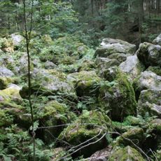
Kaser Steinstube
2.6 km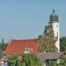
Katholische Pfarrkirche St. Maria Patrona Bavariae
139 m
Zugehöriger Südostflügel
2.4 km
Bauernhaus eines Vierseithofes
251 m
Bauernhaus eines Vierseithofes
747 m
Rottaler Bauernhaus eines Vierseithofes
2.8 km
Stallstadel Grasberg 1 in Wittibreut
2.8 km
Altbachgebiet südwestlich Triftern
2.3 km
Rottaler Bauernhaus eines Vierseithofes
2.8 km
Bauernhaus eines Vierseithofes
2.3 km
Bauernhaus eines Vierseithofs
2.4 km
Rottaler Bauernhaus eines Vierseithofes
2.4 km
Wohnstallhaus
2.8 km
Zugehöriges Mühlengebäude
1.4 km
Zugehörig Traidkasten
1.5 km
Stadel
2.8 km
Einfirsthof
2.8 km
Remise Grasberg 1 in Wittibreut
2.8 km
Bauernhaus
2.5 km
Geotop "Kaser Steinstuben"
2.7 km
Wayside cross
2.1 km
Wayside cross
2.9 km
Wayside shrine
2.4 km
Wayside cross
432 m
Wayside cross
2.2 km
Wayside cross
2.7 km
Catholic church building, wayside cross, Christianity
2.6 km
Wayside cross
2.5 kmReviews
Visited this place? Tap the stars to rate it and share your experience / photos with the community! Try now! You can cancel it anytime.
Discover hidden gems everywhere you go!
From secret cafés to breathtaking viewpoints, skip the crowded tourist spots and find places that match your style. Our app makes it easy with voice search, smart filtering, route optimization, and insider tips from travelers worldwide. Download now for the complete mobile experience.

A unique approach to discovering new places❞
— Le Figaro
All the places worth exploring❞
— France Info
A tailor-made excursion in just a few clicks❞
— 20 Minutes