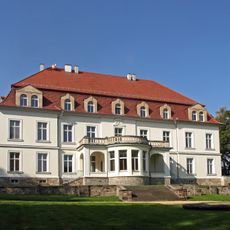
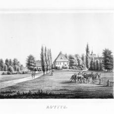
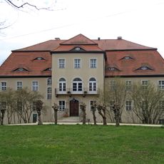
Schloss Wurschen, Baroque château in Weißenberg, Germany
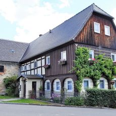
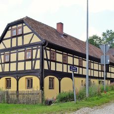
The main building features eleven axes across two floors, crowned by a steep mansard roof and a prominent three-axis central projection rising above.
During the Napoleonic Wars in 1813, Schloss Wurschen served as headquarters for Prussian forces and residence of King Friedrich Wilhelm III.
The structure belongs to the Rittergut und Gutspark complex, representing Saxon nobility architecture with preserved water-filled moats from medieval times.
The château currently functions as a private residence while offering holiday apartment accommodations for visitors interested in experiencing manor life.
The foundation rests entirely on wooden piles, with an artificial water system specifically designed to protect this distinctive construction method.
Location: Weißenberg
Inception: 1750
Part of: Rittergut und Gutspark Wurschen (Sachgesamtheit) Schloßplatz 2, 4, 5, 6, 7, 10, 12
Address: Schloßplatz 2, 4, 5, 6, 10, 12
GPS coordinates: 51.19319,14.58282
Latest update: March 14, 2025 12:37
Jan-Kilian-Denkmal
2.8 km
Steindeckerbrücke über das Löbauer Wasser Zum Löbauer Wasser (am Ortsausgang Rackel in Richtung Preititz)
2.6 km
Kirche Kotitz
2.8 km
Dom Měrćina Nowaka-Njechorńskeho
1.1 km
Fürstengrab Drehsa
2.2 km
Holländermühle Rodewitz
2.5 km
Krujatzmühle Rodewitz
2.8 km
Riegel-Mühle
1.6 km
Evakreuz
340 m
Am Schmiedeberg 1
2 km
Dorfstraße 37
2.1 km
Mühle Elle
2.4 km
Rittergut Kotitz (Sachgesamtheit) Jan-Kilian-Straße 2, 4, 6
2.7 km
Rittergut und Gutspark Wurschen (Sachgesamtheit) Schloßplatz 2, 4, 5, 6, 7, 10, 12
37 m
Schmiede mit Oberlaube Am Schmiedeberg 2
2 km
Wohnhaus (Umgebinde) An der Schäferei 2
2 km
Dorfstraße 24
2 km
Cortnitz 7
3.2 km
Friedhofshalle Jan-Kilian-Straße (auf dem Friedhof)
3.1 km
Denkmal für die Gefallenen des Ersten Weltkrieges, mit Ehrenhain Jan-Kilian-Straße (neben dem Friedhof)
3 km
Cortnitz 16
3.1 km
Wegestein bei Kumschütz 6 (am Ortseingang)
3.2 km
Wohnhaus Rackeler Dorfstraße 24 (ehemals Baruther Straße 24)
2.5 km
Steinbankweg (Steinerner Kirchweg) Riegelstraße (Straße von Nechern nach Brießnitz/Gröditz)
1.3 km
Steinkreuz (am Ortseingang, von Baruth kommend)
2.5 km
Cortnitz 8
3.2 km
Wohnhaus, Scheune, zwei Seitengebäude und Taubenhaus eines Vierseithofes Am Berg 18, 18a
2.6 km
Schwedenstein; Denkmal (300 Meter westlich vom nördlichen Ortsausgang von Nechern, am Rande einer Wiese)
964 mReviews
Visited this place? Tap the stars to rate it and share your experience / photos with the community! Try now! You can cancel it anytime.
Discover hidden gems everywhere you go!
From secret cafés to breathtaking viewpoints, skip the crowded tourist spots and find places that match your style. Our app makes it easy with voice search, smart filtering, route optimization, and insider tips from travelers worldwide. Download now for the complete mobile experience.
A unique approach to discovering new places❞
— Le Figaro
All the places worth exploring❞
— France Info
A tailor-made excursion in just a few clicks❞
— 20 Minutes