Klamme mit Nagelfluhfelsen, protected landscape in Bavaria, Germany
Location: Rottal-Inn
Inception: 1960
GPS coordinates: 48.37587,13.04417
Latest update: November 20, 2025 12:51
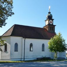
Katholische Filialkirche Hl. Theresia
730 m
Enges Tal in der Gemeinde Ulbering
1.1 km
Klamme südlich von Ecking in der Gemeinde Wiesing
563 m
Rottaler Bauernhaus eines Vierseithofes
1.4 km
Bauernhaus mit Blockbau-Obergeschoss
2.4 km
Bauernhaus eines Vierseithofes
2.4 km
Stallstadel mit Andreaskreuz-Bundwerk
1.3 km
Zugehöriger Südostflügel
898 m
Bauernhaus eines Vierseithofes
2 km
Getreidekasten
2.3 km
Stallstadel Grasberg 1 in Wittibreut
1.4 km
Ehem. Einfirsthof
2.5 km
Stattlicher Vierseithof
1.2 km
Stall Flur Au in Bad Birnbach
2.5 km
Stallstadel auf der Südseite des Hofes
1.4 km
Wohnstallhaus mit Blockbau-Obergeschoss
1.4 km
Zugehörig Traidkasten
2 km
Einfirsthof
1.8 km
Bauernhaus eines Vierseithofes
2.1 km
Bauernhaus
1.2 km
Stall Steinbach 3 in Triftern
1.2 km
Scheune Steinbach 3 in Triftern
1.2 km
Scheune Hartmannsberg 2 in Wittibreut
2 km
Remise Grasberg 1 in Wittibreut
1.4 km
Bauernhaus eines Vierseithofs
1.6 km
Stallstadel Hartmannsberg 2 in Wittibreut
2 km
Stall Steinbach 3 in Triftern
1.2 km
Wayside cross
2.4 kmReviews
Visited this place? Tap the stars to rate it and share your experience / photos with the community! Try now! You can cancel it anytime.
Discover hidden gems everywhere you go!
From secret cafés to breathtaking viewpoints, skip the crowded tourist spots and find places that match your style. Our app makes it easy with voice search, smart filtering, route optimization, and insider tips from travelers worldwide. Download now for the complete mobile experience.

A unique approach to discovering new places❞
— Le Figaro
All the places worth exploring❞
— France Info
A tailor-made excursion in just a few clicks❞
— 20 Minutes