Pegel Maxau, Stream gauge on the Rhine in Knielingen, Karlsruhe, Germany
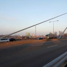
Pegel Maxau is a river gauge for Rhine shipping on the right bank at Rhine kilometre 362.3, in the Karlsruhe district of Knielingen between the Rhine bridges and the entrance to the Maxau yacht harbour. Its gauge zero lies at 97.72 metres above sea level, and the Wasserstraßen- und Schifffahrtsamt Oberrhein operates it and keeps a service building at the site.
The measurement station was established to systematically document the Rhine's water levels and support navigation and water management. Over time, the station became part of Germany's flood warning systems.
The gauge is a reference point for the Upper Rhine between the Iffezheim lock at kilometre 334 and Germersheim at kilometre 384. At the high-water mark II of 750 cm, shipping in this stretch is largely stopped and the flood gate of Karlsruhe's Rhine harbour is closed. The mean water level is 523 cm; on 14 May 1999 it reached 884 cm.
The gauge stands on the right bank at Rhine kilometre 362.3, between the Rhine bridges and the entrance to Maxau yacht harbour in Karlsruhe's Knielingen district; the waterway authority maintains a service building there. Readings are published online in real time for skippers and authorities. The gauge zero lies at 97.72 m above sea level.
The station's data feeds into a large network of measurement points that spans multiple countries along the Rhine, enabling cross-border water management. This makes Maxau part of an international monitoring infrastructure.
The community of curious travelers
AroundUs brings together thousands of curated places, local tips, and hidden gems, enriched daily by 94,215 contributors worldwide.