Valmy, Administrative division in Marne department, France.
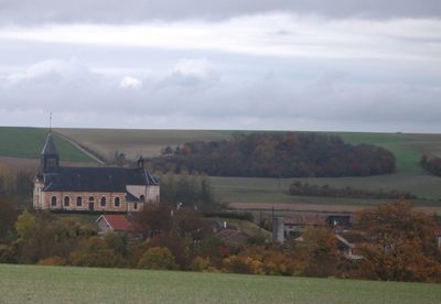
Valmy extends over 24 square kilometers of rural terrain in the Grand Est region, with elevations ranging between 140 and 213 meters above sea level.
The Battle of Valmy in 1792 marked a turning point in French military history, leading to the establishment of the First French Republic.
The administrative center maintains regional archives and documents that detail the evolution of local governance structures through multiple centuries.
The town hall at 30 rue André-Procureur opens Monday 8:00-19:00, Wednesday 13:30-18:00, and Thursday 13:30-19:00, providing administrative services to residents.
The geographical position of Valmy places it exactly 180 kilometers from Paris and 58 kilometers from Rheims, making it a central point in regional administration.
Location: canton of Sainte-Menehould
Location: Marne
Location: arrondissement of Châlons-en-Champagne
Elevation above the sea: 172 m
Shares border with: Auve, Braux-Sainte-Cohière, La Chapelle-Felcourt, La Croix-en-Champagne, Dommartin-Dampierre, Dommartin-sous-Hans, Gizaucourt, Hans, Maffrécourt, Saint-Mard-sur-Auve, Somme-Bionne
Address: 30 rue André-Procureur, 51800 Valmy 51800
Phone: +33326602719
Email: mairiedevalmy@orange.fr
GPS coordinates: 49.08444,4.77361
Latest update: May 27, 2025 13:26
Moulin de Valmy
695 m
Pont-du-Marson National Cemetery
11.2 km
Église Notre-Dame-du-Soldat de Hans
3.3 km
St-Martin (Auve)
8.1 km
Église Saint-Charles de Sainte-Menehould
8.9 km
Église Saint-Remi de Braux-Saint-Remy
9.6 km
Église Notre-Dame-du-Château de Sainte-Menehould
8.9 km
Église Saint-Laurent de Rapsécourt
6.9 km
Église Saint-Georges d'Herpont
10.2 km
Église Saint-Didier de Verrières
9.9 km
Église Saint-Martin de Dommartin-sous-Hans
4.6 km
Église Saint-Pierre de Courtémont
5.4 km
Église Saint-Pierre-ès-Liens de Braux-Sainte-Cohière
4.1 km
Église Saint-Sylvin de La Croix-en-Champagne
9.4 km
Église Saint-Martin de Valmy
237 m
Église Saint-Étienne de Somme-Bionne
3.8 km
Église Saint-Martin de Somme-Tourbe
8 km
Église de la Nativité-de-Saint-Jean de Saint-Jean-sur-Tourbe
8.4 km
Salle des Fêtes de Sainte-Menehould
9.1 km
Caisse d'Épargne
9.1 km
Église Saint-Julien à Élise
8 km
Château de Braux-Sainte-Cohière
4 km
Église Sainte-Marie-Madeleine de Moiremont
9.9 km
Église Saint-Nicolas de Daucourt
9.3 km
Town hall of Sainte-Menehould
9.2 km
Chapelle de la princesse de Ginetti de Valmy
688 m
Chapelle de l'hospice de Sainte-Menehould
8.6 km
Chapelle Saint-Charles de Sainte-Menehould
8.8 kmReviews
Visited this place? Tap the stars to rate it and share your experience / photos with the community! Try now! You can cancel it anytime.
Discover hidden gems everywhere you go!
From secret cafés to breathtaking viewpoints, skip the crowded tourist spots and find places that match your style. Our app makes it easy with voice search, smart filtering, route optimization, and insider tips from travelers worldwide. Download now for the complete mobile experience.
A unique approach to discovering new places❞
— Le Figaro
All the places worth exploring❞
— France Info
A tailor-made excursion in just a few clicks❞
— 20 Minutes