Enable Location

We need your location to show you interesting places around you

Discover nearby places

Find interesting locations and hidden gems around you

Precise directions

Get accurate directions and distances to places

Your location is never shared with other users. It's only used when you tap the location button.

Ferrier of Tannerre-en-Puisaye

Log in to your account

Start exploring — it's free

Trusted by 61,995 travelers worldwide

Continue with Google
Continue with Apple
or

We will send you a code to connect

By continuing, you accept our Terms and Conditions and our Privacy Policy

Check your inbox

We've sent a pincode in your inbox. Please enter the code below.

Ferrier of Tannerre-en-Puisaye

Ferrier of Tannerre-en-Puisaye, Ancient iron mining site in Tannerre-en-Puisaye, France.

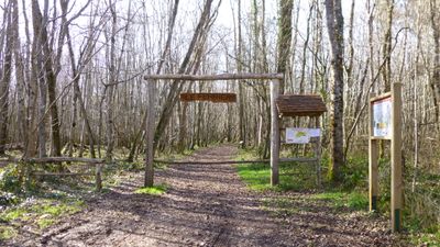
The Ferrier of Tannerre-en-Puisaye is an ancient iron mining site spread across woodland terrain with multiple extraction pits and slag heaps marking the landscape. The grounds show clear traces of resource extraction through natural depressions and earth mounds that shape the terrain.

The site operated as a major iron production center during Roman times, processing ore through basic furnaces across the terrain. A medieval fortification was built here in the 10th century to defend an important trade route.

The medieval fortress Motte Champlay was constructed on the mining grounds in the 10th century to protect the road leading to Paris.

Visitors follow marked trails with information panels that guide them through the site and explain its past uses. Woodland conditions vary by season, so sturdy footwear is advisable.

After centuries of iron extraction, the grounds continued to be worked for slag recovery until 1982 before gaining protected status. This later industrial phase left additional layers visible in the landscape today.

The community of curious travelers

AroundUs brings together thousands of curated places, local tips, and hidden gems, enriched daily by 60,000 contributors worldwide.

Start exploring
Address
La Garenne
GPS coordinates
47.73860,3.13293
Latest update
December 9, 2025 20:26
« Ferrier of Tannerre-en-Puisaye - Ancient iron mining site in Tannerre-en-Puisaye, France » is provided by Around Us (aroundus.com). Images and texts are derived from Wikimedia project under a Creative Commons license. You are allowed to copy, distribute, and modify copies of this page, under the conditions set by the license, as long as this note is clearly visible.

Discover hidden gems everywhere you go!

From secret cafés to breathtaking viewpoints, skip the crowded tourist spots and find places that match your style. Our app makes it easy with voice search, smart filtering, route optimization, and insider tips from travelers worldwide. Download now for the complete mobile experience.

Around Us App Screenshot

A unique approach to discovering new places

Le Figaro

All the places worth exploring

France Info

A tailor-made excursion in just a few clicks

20 Minutes

Around Us
Travel Guide & Maps
Download

Send to your phone

QR Code
1

Open the camera app on your mobile.

2

Point at the QR code with your camera. A notification will appear.

3

Tap the notification to open the link.