Enable Location

We need your location to show you interesting places around you

Discover nearby places

Find interesting locations and hidden gems around you

Precise directions

Get accurate directions and distances to places

Your location is never shared with other users. It's only used when you tap the location button.

Vézoles Lake

Log in to your account

Start exploring — it's free

Trusted by 62,492 travelers worldwide

Continue with Google
Continue with Apple
or

We will send you a code to connect

By continuing, you accept our Terms and Conditions and our Privacy Policy

Check your inbox

We've sent a pincode in your inbox. Please enter the code below.

Vézoles Lake

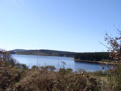
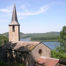
Vézoles Lake, Lac of Hérault (France)

Vézoles Lake is a reservoir in southwestern France located in the Hérault region near the villages of Fraisse-sur-Agout and Prémian. The body of water is surrounded by rolling hills and mixed forests, with accessible pathways running along its shoreline.

The lake was created in 1956 when a dam was built to provide water for surrounding communities and farming. Since its establishment, this body of water has become a popular destination for outdoor recreation.

The name Vézoles connects to the water heritage of this region. Today, the lake serves as a gathering place where local people spend time outdoors and maintain their connection to the land.

To reach the lake, follow the D 907 road from Saint-Pons-de-Thomières to Col du Cabarétou, where two parking areas are available. The site provides picnic spots and grills on location, with marked walking trails that are easy to follow.

The lake sits on a watershed that divides two major river basins, meaning water flows from here in two different directions toward different seas. This geographical feature makes the spot a significant point on regional hiking maps.

The community of curious travelers

AroundUs brings together thousands of curated places, local tips, and hidden gems, enriched daily by 60,000 contributors worldwide.

Start exploring
Location
Location
GPS coordinates
43.55626,2.79636
Latest update
February 9, 2026 08:23
Around this place
Saint-Pons-de-Thomières Cathedral
France

Saint-Pons-de-Thomières Cathedral

8.1 km
Pont du Diable
France

Pont du Diable

9.3 km
Pipe organ of Cathédrale Saint-Pons de Saint-Pons-de-Thomières
France

Pipe organ of Cathédrale Saint-Pons de Saint-Pons-de-Thomières

8 km
Château d'Arifat
France

Château d'Arifat

9.5 km
Église Saint-Laurent d'Olargues
France

Église Saint-Laurent d'Olargues

9.4 km
Chapelle de Saint Étienne de Cavall
France

Chapelle de Saint Étienne de Cavall

9.7 km
Pont de Saint-Étienne de la Salvetat-sur-Agout
France

Pont de Saint-Étienne de la Salvetat-sur-Agout

9 km
Musée de préhistoire régionale de Saint-Pons-de-Thomières
France

Musée de préhistoire régionale de Saint-Pons-de-Thomières

8.1 km
Église de Saint Étienne de La Salvetat-sur-Agout
France

Église de Saint Étienne de La Salvetat-sur-Agout

9.7 km
Église Saint-Martin-du-Jaur de Saint-Pons-de-Thomières
France

Église Saint-Martin-du-Jaur de Saint-Pons-de-Thomières

8.2 km
Église Saint-Sébastien de La Caminade
France

Église Saint-Sébastien de La Caminade

4.3 km
Église Notre-Dame de Villelongue de Nages
France

Église Notre-Dame de Villelongue de Nages

8.9 km
Fontaine de la République
France

Fontaine de la République

8.1 km
Église Saint-Pierre-et-Saint-Paul de Cambon
France

Église Saint-Pierre-et-Saint-Paul de Cambon

8.6 km
Église Saint-Jean du Soulié
France

Église Saint-Jean du Soulié

8.6 km
Église Saint-Pierre-et-Saint-Paul de Mauroul
France

Église Saint-Pierre-et-Saint-Paul de Mauroul

7.3 km
Église de la Nativité-de-Saint-Jean-Baptiste de Fraisse-sur-Agout
France

Église de la Nativité-de-Saint-Jean-Baptiste de Fraisse-sur-Agout

5.5 km
Église de la Nativité-de-Notre-Dame d'Ardouane
France

Église de la Nativité-de-Notre-Dame d'Ardouane

4.2 km
Église Saint-Pierre de Riols
France

Église Saint-Pierre de Riols

5.6 km
Église Saint-Mathias de Marthomis
France

Église Saint-Mathias de Marthomis

9.2 km
Église Saint-Vincent de Saint-Vincent-d'Olargues
France

Église Saint-Vincent de Saint-Vincent-d'Olargues

6.7 km
Olargues war memorial
France

Olargues war memorial

9.5 km
Hôtel de ville de Saint-Pons-de-Thomières
France

Hôtel de ville de Saint-Pons-de-Thomières

8.1 km
Chapelle Notre-Dame-du-Jaur de Saint-Pons-de-Thomières
France

Chapelle Notre-Dame-du-Jaur de Saint-Pons-de-Thomières

8.4 km
Chapelle des pénitents de Saint-Pons-de-Thomières
France

Chapelle des pénitents de Saint-Pons-de-Thomières

8.3 km
Chapelle de Notre-Dame de Trédos
France

Chapelle de Notre-Dame de Trédos

7 km
Chapelle Saint-Martin-des-Œufs d'Olargues
France

Chapelle Saint-Martin-des-Œufs d'Olargues

8.5 km
Chapelle Saint-Roch d'Olargues
France

Chapelle Saint-Roch d'Olargues

9.2 km
Show the full map
« Vézoles Lake - Lac of Hérault (France) » is provided by Around Us (aroundus.com). Images and texts are derived from Wikimedia project under a Creative Commons license. You are allowed to copy, distribute, and modify copies of this page, under the conditions set by the license, as long as this note is clearly visible.

Discover hidden gems everywhere you go!

From secret cafés to breathtaking viewpoints, skip the crowded tourist spots and find places that match your style. Our app makes it easy with voice search, smart filtering, route optimization, and insider tips from travelers worldwide. Download now for the complete mobile experience.

Around Us App Screenshot

A unique approach to discovering new places

Le Figaro

All the places worth exploring

France Info

A tailor-made excursion in just a few clicks

20 Minutes

Around Us
Travel Guide & Maps
Download

Send to your phone

QR Code
1

Open the camera app on your mobile.

2

Point at the QR code with your camera. A notification will appear.

3

Tap the notification to open the link.