Rocher aux Oiseaux, Granite summit in Charente, France
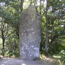
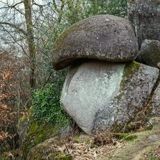
Rocher aux Oiseaux is the highest point of the Charente department, at 368.63 m, on the commune of Montrollet in Charente limousine, 19 km east of Confolens. It lies on the wooded hill at the north-eastern tip of the department, on the edge of Haute-Vienne, where the last branches of the monts de Blond meet the Limousin plateau. The bedrock is granite and leucogranite cut by a band of quartz; in the photograph a rounded grey and white boulder overhangs a smaller base stone, beside a wooden signpost marked "368m63".
For a long time, l'Arbre, 12 km east of La Rochefoucauld, was considered the highest point of Charente at 353 m. Surveys later established that the Rocher aux Oiseaux, on the Montrollet commune, reaches 368.63 m, making it the department's summit.
The name Rocher aux Oiseaux refers to the birds drawn to this wooded hilltop, the highest point of the Charente at 368.63 m, on the Montrollet commune near the Haute-Vienne border. A wooden signpost beside the granite boulder reads "368m63", marking the altitude for walkers.
The summit lies in the Charente limousine, 19 km east of Confolens on the wooded hill at the north-eastern edge of the department, beside the Haute-Vienne boundary. A wooden post on the grass carries the white marking "368m63", the exact altitude. The granite boulder stands just beside it.
The summit's name comes from the birds drawn to the wooded hill, and the granite boulder in the photograph carries a wooden sign reading "368m63" — the altitude in metres. Until surveys corrected it, l'Arbre, 12 km east of La Rochefoucauld, was long held to be Charente's highest point at 353 m.
The community of curious travelers
AroundUs brings together thousands of curated places, local tips, and hidden gems, enriched daily by 94,325 contributors worldwide.