Chest opened
+${chestReward.xp} XP
Explorer
NOUVEAU ×${chestReward.collectible.quantity}
tapez pour fermer

See the monuments around you in AR Open chests in the app

Around Us is built for your phone — point your camera at the streets and discover the monuments and places around you in augmented reality. Around Us is built for your phone — chests unlock when you walk, explore and capture nearby places.

•

Enable Location

We need your location to show you interesting places around you

Discover nearby places

Find interesting locations and hidden gems around you

Precise directions

Get accurate directions and distances to places

Your location is never shared with other users. It's only used when you tap the location button.

Pourrhis viaduct

Log in to your account

Start exploring — it's free

Trusted by 94,658 travelers worldwide

Continue with Google
Continue with Apple
or

We will send you a code to connect

By continuing, you accept our Terms and Conditions and our Privacy Policy

Check your inbox

We've sent a pincode in your inbox. Please enter the code below.

Pourrhis viaduct, Abandoned railway bridge in Binic-Étables-sur-Mer, France

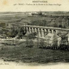
The Pourrhis viaduct (or Sieurnes viaduct) is a railway bridge in Binic-Étables-sur-Mer, built by Louis Harel de la Noë for the Côtes-du-Nord railways. It has 10 arches, measures 91.8 m long and 16.9 m high, and carries a pyramid- or diamond-point-shaped escutcheon. It spans the Ponto valley, where the Vau Durand stream flows beneath it.

The viaduct was built by engineer Louis Harel de la Noë for the Côtes-du-Nord railway company on the Saint-Brieuc to Plouha line, opened on 20 June 1905 and called the "jewel of the first network". Five trains used it each year until the line closed in 1956. After nearly 50 years of closure it was cleared and secured in 2007 by the Association pour la réhabilitation du Viaduc des Pourrhis.

The viaduct is accessible on foot or by bike along a trail that follows the old railway embankment, and sturdy footwear is a good idea since the surrounding paths are unpaved dirt roads. The site has no visitor facilities on-site, so it is best to plan accordingly before arriving.

Louis Harel de la Noë gave this viaduct a detail found on none of his other structures: a shield shaped like a pyramid or a diamond point, set on the masonry. Look for it while crossing. The arches themselves were singled out as particularly carefully built.

The community of curious travelers

AroundUs brings together thousands of curated places, local tips, and hidden gems, enriched daily by 94,658 contributors worldwide.

Start exploring
Location
Binic-Étables-sur-Mer
Height
16.5 m
Length
91.8 m
Address
22680 Binic-Étables-sur-Mer, France
GPS coordinates
48.63532,-2.84143
Latest update
October 26, 2026 09:43
Reviews
Share your experience

No review yet

Discussions
Start a discussion...

No discussion yet

« Pourrhis viaduct - Abandoned railway bridge in Binic-Étables-sur-Mer, France » is provided by Around Us (aroundus.com). Images and texts are derived from Wikimedia project under a Creative Commons license. You are allowed to copy, distribute, and modify copies of this page, under the conditions set by the license, as long as this note is clearly visible.

Discover hidden gems everywhere you go!

From secret cafés to breathtaking viewpoints, skip the crowded tourist spots and find places that match your style. Our app makes it easy with voice search, smart filtering, route optimization, and insider tips from travelers worldwide. Download now for the complete mobile experience.

Around Us App Screenshot
❝

A unique approach to discovering new places❞

— Le Figaro

❝

All the places worth exploring❞

— France Info

❝

A tailor-made excursion in just a few clicks❞

— 20 Minutes

Around Us
Travel Guide & Maps
Download

Send to your phone

QR Code
1

Open the camera app on your mobile.

2

Point at the QR code with your camera. A notification will appear.

3

Tap the notification to open the link.