Letaja, Berggipfel in Kroatien
Location: Dubrovnik-Neretva County
GPS coordinates: 42.58722,18.25194
Latest update: November 16, 2025 21:52

Đurovića špilja
3.2 km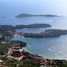
Župski Zaljev
4 km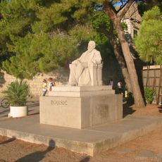
Bogišić
2.9 km
Oštri Kuk (tumoy sa bukid)
895 m
Crni Kuk
3.7 km
Ivanov Krst
4.2 km
Humak
1.1 km
Kurilo
2 km
Debeli Vrh (tumoy sa bukid)
4.6 km
Golubinac (tumoy sa bukid)
4.5 km
Gnjile
3.5 km
Plat
3.2 km
Lokanj
3.4 km
FKK
3.5 km
Scenic viewpoint
2.3 km
Nudist beach
2.3 km
Franjo Tuđman
2.9 km
Scenic viewpoint
463 m
Scenic viewpoint
2.4 km
Beach
2.3 km
FKK Nudist Beach
2.4 km
Scenic viewpoint
4.2 km
Archaeological site
3.3 km
Frano Supilo 1870-1917
3.1 km
Wayside cross
3.4 km
Spomenik poginulima u požaru 2019.
2.6 km
Mitrej
2.7 km
Vlaho Bukovac
3.1 kmReviews
Visited this place? Tap the stars to rate it and share your experience / photos with the community! Try now! You can cancel it anytime.
Discover hidden gems everywhere you go!
From secret cafés to breathtaking viewpoints, skip the crowded tourist spots and find places that match your style. Our app makes it easy with voice search, smart filtering, route optimization, and insider tips from travelers worldwide. Download now for the complete mobile experience.

A unique approach to discovering new places❞
— Le Figaro
All the places worth exploring❞
— France Info
A tailor-made excursion in just a few clicks❞
— 20 Minutes