Bhandara district, Administrative district in Nagpur division, India
Bhandara district is an administrative division in the Nagpur region that spreads across farmland and several river systems supporting the local economy. The area consists of smaller towns and rural settlements centered on agricultural production and traditional livelihoods.
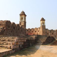
The region traces back to ancient times, with inscriptions at Ratanpur from the 11th century reflecting the origin of its name. It was subsequently shaped by various rulers who administered the area across different periods.
Different communities here maintain their traditions through local festivals and crafts that shape daily life. Markets and gathering spaces serve as centers where people actively express and share these practices with one another.
The region is organized into three administrative units that function as local governance centers. Visiting during harvest seasons allows you to observe farming activities and local market life at their most active.
Tumsar serves as a major trading hub for rice in the region, shaping much of the district's economic character. The city of Bhandara itself maintains a strong tradition of brass manufacturing that gives it a distinct craft identity.
The community of curious travelers
AroundUs brings together thousands of curated places, local tips, and hidden gems, enriched daily by 60,000 contributors worldwide.