Enable Location

We need your location to show you interesting places around you

Discover nearby places

Find interesting locations and hidden gems around you

Precise directions

Get accurate directions and distances to places

Your location is never shared with other users. It's only used when you tap the location button.

Monte Tinisa

Log in to your account

Start exploring — it's free

Trusted by 62,144 travelers worldwide

Continue with Google
Continue with Apple
or

We will send you a code to connect

By continuing, you accept our Terms and Conditions and our Privacy Policy

Check your inbox

We've sent a pincode in your inbox. Please enter the code below.

Monte Tinisa

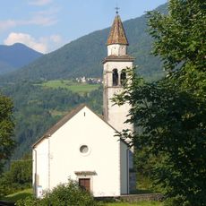
Monte Tinisa, Alpine summit in Friuli Venezia Giulia, Italy

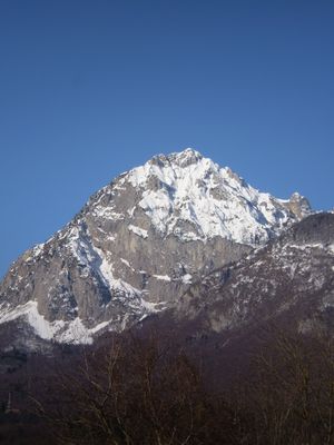
Monte Tinisa rises to 2120 meters in the Carnic and Gailtal Alps, forming a distinct rock pyramid visible from the Sauris region. Multiple routes lead to its peak, each offering different terrain and difficulty levels as they converge at the summit.

The established Sentiero attrezzato De Monte Pascul links this peak with two others in this section of the Italian Alps, creating a historic connection between them. The trail developed as an important route crossing this alpine region.

The summit lies where Italian and Austrian mountain cultures meet, blending regional climbing styles and trail marking practices from both sides. This cross-border character shapes how visitors experience the ascent.

The main access begins at Passo del Pura, where parking is available approximately 500 meters before the trail starts. Proper mountain boots and preparation for alpine conditions are needed, as the ascent includes steep sections with significant elevation gain.

The rock formation has a special quality: from different angles, the pyramid appears to change its profile and shape significantly. Hikers often notice that the view from the north looks entirely different compared to approaching from the south.

The community of curious travelers

AroundUs brings together thousands of curated places, local tips, and hidden gems, enriched daily by 60,000 contributors worldwide.

Start exploring
Elevation above the sea
2,120 m
GPS coordinates
46.41353,12.71838
Latest update
December 14, 2025 20:30
« Monte Tinisa - Alpine summit in Friuli Venezia Giulia, Italy » is provided by Around Us (aroundus.com). Images and texts are derived from Wikimedia project under a Creative Commons license. You are allowed to copy, distribute, and modify copies of this page, under the conditions set by the license, as long as this note is clearly visible.

Discover hidden gems everywhere you go!

From secret cafés to breathtaking viewpoints, skip the crowded tourist spots and find places that match your style. Our app makes it easy with voice search, smart filtering, route optimization, and insider tips from travelers worldwide. Download now for the complete mobile experience.

Around Us App Screenshot

A unique approach to discovering new places

Le Figaro

All the places worth exploring

France Info

A tailor-made excursion in just a few clicks

20 Minutes

Around Us
Travel Guide & Maps
Download

Send to your phone

QR Code
1

Open the camera app on your mobile.

2

Point at the QR code with your camera. A notification will appear.

3

Tap the notification to open the link.