Enable Location

We need your location to show you interesting places around you

Discover nearby places

Find interesting locations and hidden gems around you

Precise directions

Get accurate directions and distances to places

Your location is never shared with other users. It's only used when you tap the location button.

Cavalcavia Monte Ceneri-Serra

Log in to your account

Start exploring — it's free

Trusted by 63,027 travelers worldwide

Continue with Google
Continue with Apple
or

We will send you a code to connect

By continuing, you accept our Terms and Conditions and our Privacy Policy

Check your inbox

We've sent a pincode in your inbox. Please enter the code below.

Cavalcavia Monte Ceneri-Serra
Discussion Reviews 1 Photos
3.1k Popularity

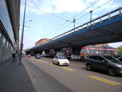
Cavalcavia Monte Ceneri-Serra, Elevated road in northwest Milan, Italy.

The Cavalcavia Monte Ceneri-Serra is an elevated viaduct that connects Viale Monte Ceneri with Viale Renato Serra in northwest Milan. The 1800-meter structure consists of two separate viaducts, including one that spans 350 meters over another street and another that extends about 1 kilometer before reaching the Ponte della Ghisolfa bridge.

The viaduct was designed by engineers Silvano Zorzi and Giorgio Macchi in 1965 as part of Milan's post-war infrastructure modernization efforts. It was built during a period when the city was expanding its road network to handle increasing traffic demands.

The viaduct reflects 1960s Italian engineering values through its design with central support pillars and tapered outer sections. Drivers and pedestrians passing above notice how these features create a sense of visual lightness across the structure.

The viaduct is straightforward to navigate since it provides a direct connection between two main streets and integrates clearly into the urban traffic system. Note that the structure passes over multiple street levels and is visible from various vantage points throughout the area.

The structure maintains a thin, continuous ribbon appearance along its entire length through specialized concrete techniques that were innovative for the 1960s. This engineering refinement demonstrates the precision involved in constructing major infrastructure during that era.

The community of curious travelers

AroundUs brings together thousands of curated places, local tips, and hidden gems, enriched daily by 60,000 contributors worldwide.

Start exploring
Location
Inception
1965
Length
1,800 m
Part of
Circonvallazione esterna
GPS coordinates
45.48967,9.15093
Latest update
December 12, 2025 09:07
Reviews
Share your experience

No review yet

Discussions
Start a discussion...

No discussion yet

« Cavalcavia Monte Ceneri-Serra - Elevated road in northwest Milan, Italy » is provided by Around Us (aroundus.com). Images and texts are derived from Wikimedia project under a Creative Commons license. You are allowed to copy, distribute, and modify copies of this page, under the conditions set by the license, as long as this note is clearly visible.

Discover hidden gems everywhere you go!

From secret cafés to breathtaking viewpoints, skip the crowded tourist spots and find places that match your style. Our app makes it easy with voice search, smart filtering, route optimization, and insider tips from travelers worldwide. Download now for the complete mobile experience.

Around Us App Screenshot

A unique approach to discovering new places

Le Figaro

All the places worth exploring

France Info

A tailor-made excursion in just a few clicks

20 Minutes

Around Us
Travel Guide & Maps
Download

Send to your phone

QR Code
1

Open the camera app on your mobile.

2

Point at the QR code with your camera. A notification will appear.

3

Tap the notification to open the link.