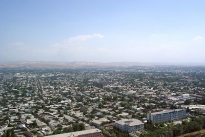
Osh, Ancient trading city in southern Kyrgyzstan.
Osh is a first-level administrative division in southern Kyrgyzstan that follows the course of the Akbura River at an elevation of nine hundred and sixty-three meters (3160 feet). The five-peaked Sulaiman-Too mountain rises at the center, dominating the cityscape with its rocky slopes and caves that have been inscribed on the World Heritage List.
The city began as a trading post along the Silk Road and connected merchants from China, India, and Europe during the fifteenth century through its position on major caravan routes. The center remained in the same location for over two thousand years and grew into a crossroads between the high mountain regions and the southern plains.
The central bazaar of Osh maintains its original location after 2000 years, offering local products, textiles, and traditional foods from diverse ethnic communities.
Several daily flights connect the international airport to Bishkek, and the city provides access to mountain regions in the south of the country. The elevation can cause mild shortness of breath on arrival, so it helps to take the first day slowly.
The rocks of Sulaiman-Too hold petroglyphs from different centuries, and the caves shelter two mosques from the sixteenth century that remain in use for religious purposes. Visitors can reach the summits along steep trails that wind between the rock faces.
Location: Kyrgyzstan
Elevation above the sea: 963 m
Shares border with: Osh Region
Website: http://oshcity.gov.kg
GPS coordinates: 40.53619,72.80336
Latest update: December 4, 2025 19:02
Sulaiman-Too
1.9 km
Kempir-Abad reservoir
37 km
Osh State Academic Uzbek Music and Drama Theater named after Babur
1.3 km
National Historical and Archaeological Museum Complex Sulayman
1.9 km
Suyumbayev Stadion
1.7 km
Church in Andijan
44.6 km
Papan Reservoir
21 km
Saint Michael Church
2.3 km
Ajidaar-Unkyur
26.2 km
Church of St. Nicholay Chudotvortsa in Andijan
44.7 km
Chapel of St. George in Andijan
43.4 km
Dangi Canyon
17.3 km
Church of St. Sergiy Radonezhckogo in Andijan
45.1 km
Rodnik Chogaden
29.3 km
Teshik-Tash-Bulak
43.2 km
Rodnik Kayragach-Mazar
38.5 km
Rodnik Iosh
43.5 km
Rodnik Chakman
23.7 km
Rodnik Kyzyl-Bulak (tubud sa Kirgistan)
34 km
Rodnik Uzuk-Dzhylga
47.5 km
Rodnik Ak-Terek
42.6 km
Rodnik Dzhiyde-Bulak (tubud sa Kirgistan, Osh Oblasty, lat 40,32, long 72,48)
36.6 km
Rodnik Toguz-Bulak (tubud sa Kirgistan, Osh Oblasty, lat 40,39, long 72,40)
37.8 km
Rodnik Shor-Bulak (tubud sa Kirgistan, Osh Oblasty, lat 40,26, long 72,40)
45.8 km
Rudnik Ulugtagskiy
36.7 km
Rodnik Merganbulak
41 km
Aryk Yangi
6.8 km
Sultan Ibraimov Dramatic Theatre
1.8 kmVisited this place? Tap the stars to rate it and share your experience / photos with the community! Try now! You can cancel it anytime.
Discover hidden gems everywhere you go!
From secret cafés to breathtaking viewpoints, skip the crowded tourist spots and find places that match your style. Our app makes it easy with voice search, smart filtering, route optimization, and insider tips from travelers worldwide. Download now for the complete mobile experience.
A unique approach to discovering new places❞
— Le Figaro
All the places worth exploring❞
— France Info
A tailor-made excursion in just a few clicks❞
— 20 Minutes