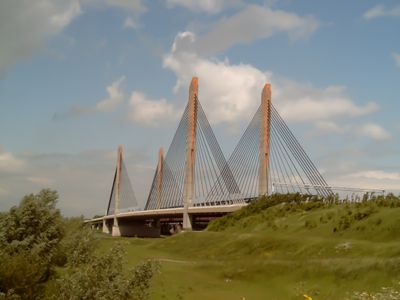
Martinus Nijhoffbrug, Cable-stayed road bridge between Neerijnen and Zaltbommel, Netherlands
The Martinus Nijhoffbrug is a cable-stayed bridge stretching nearly 1 km across the River Waal with two main towers supporting the deck through steel cables. The structure directly links the municipalities of Neerijnen and Zaltbommel over the water.
Construction of this modern bridge began in 1994 and was completed in 1996, marking a turning point in Dutch infrastructure development. It was built in response to growing traffic needs between the two riverside communities.
The bridge bears the name of Dutch poet Martinus Nijhoff, connecting engineering achievement with literary tradition. This naming choice honors a major cultural figure on a key transportation route.
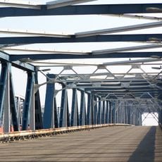
The bridge is part of the A2 motorway and is always open for vehicular traffic, with views of the Waal and surrounding countryside notable during crossing. The best vantage point for photos is from the southern shore, particularly in the afternoon.
The bridge tower rises 72 meters above the waterline, creating a distinctive landmark visible from far away. Because of this, it often serves as a navigation reference point for vessels traveling on the Waal.
Location: Neerijnen
Location: Zaltbommel
Inception: January 18, 1996
Height: 71.66 m
Length: 988.42 m
GPS coordinates: 51.81861,5.26000
Latest update: December 9, 2025 18:43
Bommelse Brug
0 m
Dr. W. Hupkesbrug
96 m
Oude watertoren Zaltbommel
488 m
Vishal
873 m
Pand met schilddak en eenvoudige, gepleisterde lijstgevel
868 m
Pand met verdieping en schilddak
876 m
Kerkplein 2, Zaltbommel
868 m
Kerkplein 26, Zaltbommel
844 m
Heilige Geeststraat 23, Zaltbommel
776 m
Kerkplein 30, Zaltbommel
843 m
Kerkstraat 5, Zaltbommel
850 m
Kerkstraat 12, Zaltbommel
876 m
Kerkstraat 10, Zaltbommel
874 m
Kerkplein 13, Zaltbommel
872 m
Kerkplein 19, Zaltbommel
822 m
De Waterman
878 m
Oenselsestraat 50, Zaltbommel
674 m
Pand met schilddak en eenvoudige, gepleisterde lijstgevel
868 m
Kerkplein 17, Zaltbommel
826 m
Pand met schilddak en gepleisterde gevel onder rechte kroonlijst
866 m
Kerkstraat 29, Zaltbommel
864 m
Kerkstraat 14, Zaltbommel
878 m
Kerkplein 28, Zaltbommel
841 m
Maasstraat 26, Zaltbommel
780 m
Oenselsestraat 17, Zaltbommel
783 m
Oenselsestraat 32, Zaltbommel
767 m
Bloemendaal 5-7, Zaltbommel
821 m
De wallen en bastions, alsmede de dubbele vestinggracht, na 1848 naar ontwerp van de stadsbouwmeester F.W. de Virieu beplant en tot singels met plantsoenaanleg getransformeerd.
688 mVisited this place? Tap the stars to rate it and share your experience / photos with the community! Try now! You can cancel it anytime.
Discover hidden gems everywhere you go!
From secret cafés to breathtaking viewpoints, skip the crowded tourist spots and find places that match your style. Our app makes it easy with voice search, smart filtering, route optimization, and insider tips from travelers worldwide. Download now for the complete mobile experience.
A unique approach to discovering new places❞
— Le Figaro
All the places worth exploring❞
— France Info
A tailor-made excursion in just a few clicks❞
— 20 Minutes