Van Brienenoordbrug, Road bridge in Rotterdam, Netherlands.
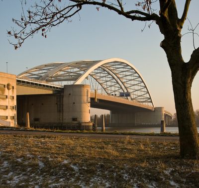
The Van Brienenoordbrug is a road bridge in Rotterdam that crosses the New Meuse River with two parallel steel arches. The structure carries traffic on two levels and spans over a kilometer in length to connect both riverbanks.
The bridge was first completed in 1965 to handle the growing traffic needs of Rotterdam at that time. A second phase was added in 1990 to accommodate further increases in transportation demand.
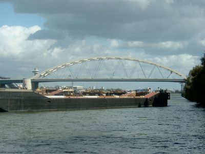
The bridge represents a key connection in Rotterdam's port-driven identity, visible to anyone crossing the river. Its presence shapes how people and goods move through the city and reflects the port's importance to daily life.
The bridge offers good views of the river and port activity for those crossing or traveling nearby. It can be experienced from vehicles, or by walking or cycling along the embankment paths that run alongside.
What many travelers overlook is how the two arches actually work with the port below: they rise high enough to let large cargo ships pass through without stopping road traffic. This dual purpose makes it more than just a highway, as it balances commerce on water and land.
Location: Rotterdam
Inception: May 1, 1990
Architects: Rijkswaterstaat
Length: 1,320 m
Longest Span: 300 m
GPS coordinates: 51.90377,4.54259
Latest update: December 7, 2025 19:28
De Kuip
1.7 km
Sportcomplex Varkenoord
1.8 km
Monument 1940-1945
568 m
2e Eiland van Brienenoordbrug
253 m
Heilige-Kruisverheffingskerk
1.7 km
Coen Moulijn
1.8 km
Zuiddiepjebrug
1.1 km
De voetballer
1.7 km
Toepad Jewish Cemetery
979 m
Adriaen Janszkerk
544 m
Benedenrijweg 455 (Rotterdam)
1.1 km
IT
1.6 km
De Arend en de Zeemeeuwbrug
1.1 km
Kralingseveerbrug
1.1 km
Benedenrijweg 435, Rotterdam
1.2 km
De Hoeksteen
1.3 km
De Rozenhof
1.1 km
Villa-achtige woning met verdieping onder samenstel van zadel- en schilddaken, opgetrokken in baksteen, afgewisseld met gele ijsselsteenbanden
1.8 km
De dobber
1.4 km
1e Eiland van Brienenoordbrug
342 m
Schaardijk 482, Rotterdam
736 m
Untitled
366 m
Plaquette in de Kuip
1.8 km
Maasbruggen
1.2 km
Ben Schopbrug
659 m
War memorial at Jewish cemetery Toepad
777 m
Boerderij, bestaande uit een parallel aan de dijk gebouwd woonhuis, onder een zadeldak met de daarnaast gelegen stal. In het woonhuis vensters met luiken en 12-ruitsschuiframen
1.3 km
Pompstationgebouw met machinekamer en ketelhuis
1.8 kmVisited this place? Tap the stars to rate it and share your experience / photos with the community! Try now! You can cancel it anytime.
Discover hidden gems everywhere you go!
From secret cafés to breathtaking viewpoints, skip the crowded tourist spots and find places that match your style. Our app makes it easy with voice search, smart filtering, route optimization, and insider tips from travelers worldwide. Download now for the complete mobile experience.
A unique approach to discovering new places❞
— Le Figaro
All the places worth exploring❞
— France Info
A tailor-made excursion in just a few clicks❞
— 20 Minutes