Enable Location

We need your location to show you interesting places around you

Discover nearby places

Find interesting locations and hidden gems around you

Precise directions

Get accurate directions and distances to places

Your location is never shared with other users. It's only used when you tap the location button.

Plompe Toren

Log in to your account

Start exploring — it's free

Trusted by 63,129 travelers worldwide

Continue with Google
Continue with Apple
or

We will send you a code to connect

By continuing, you accept our Terms and Conditions and our Privacy Policy

Check your inbox

We've sent a pincode in your inbox. Please enter the code below.

Plompe Toren
Discussion Reviews 1 Photos
6.2k Popularity

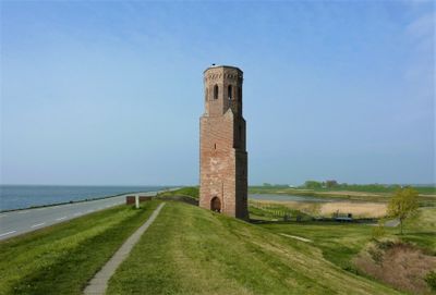
Plompe Toren, Medieval church tower in Schouwen-Duiveland, Netherlands

Plompe Toren is a church tower roughly 23 meters tall standing on the Oosterschelde coast as the only remaining structure of the former village of Koudekerke. The stone structure rises solitary above the marshland and waterways.

Built in 1468, the tower survived while fourteen villages in the region vanished between 1475 and 1650 due to rising waters and coastal erosion. It remained standing despite the same forces that destroyed all surrounding settlements.

The tower represents how coastal communities adapted to living with water and the constant threat of flooding through their buildings and choices. It stands as a reminder of villages and people who once thrived in this landscape.

Access to the top offers views across the Oosterschelde and surrounding wetlands and grasslands. The location is also a good spot to watch water birds and other wildlife.

The tower has served sailors for centuries as a navigation landmark on the Oosterschelde and is now also viewed as a work of art. Its silhouette remains a familiar sight for boaters and water travelers crossing the waterway.

The community of curious travelers

AroundUs brings together thousands of curated places, local tips, and hidden gems, enriched daily by 60,000 contributors worldwide.

Start exploring
Inception
1468
Height
23 m
Address
Koudekerkseweg 12
GPS coordinates
51.68333,3.77528
Latest update
January 24, 2026 06:29
Around this place
Haamstede Castle
Netherlands

Haamstede Castle

2.8 km
De Graanhalm
Netherlands

De Graanhalm

2.8 km
Johannes de Doperkerk
Netherlands

Johannes de Doperkerk

2.7 km
Slot Haamstede
Netherlands

Slot Haamstede

2.8 km
Weststraat 34, Haamstede
Netherlands

Weststraat 34, Haamstede

2.8 km
Huis met zadeldak, langsgevel evenwijdig aan de straat. Gepleisterde gevel. Aan de rechterzijde kelder. Stoep
Netherlands

Huis met zadeldak, langsgevel evenwijdig aan de straat. Gepleisterde gevel. Aan de rechterzijde kelder. Stoep

2.8 km
Huis onder zadeldak met langsgevel evenwijdig aan de straat. Schuiframen met negen ruiten
Netherlands

Huis onder zadeldak met langsgevel evenwijdig aan de straat. Schuiframen met negen ruiten

2.8 km
Slot Haamstede: brug met poort
Netherlands

Slot Haamstede: brug met poort

2.8 km
Slot Crayenstein
Netherlands

Slot Crayenstein

2.8 km
Smederij
Netherlands

Smederij

2.7 km
Netherlands

Terrein waarin overblijfselen van het in 1569 opgeheven en daarna afgebroken Dominicanessenklooster Leliendaal

2.6 km
Dwarshuisje van goede kwaliteit
Netherlands

Dwarshuisje van goede kwaliteit

2.7 km
Zomerzorg
Netherlands

Zomerzorg

2.9 km
Huis met door lijst afgeknotte ingezwenkte topgevel
Netherlands

Huis met door lijst afgeknotte ingezwenkte topgevel

2.7 km
Weststraat 18, Haamstede
Netherlands

Weststraat 18, Haamstede

2.8 km
Huis onder zadeldak met langsgevel aan de straat. Schuiframen met negen ruiten. Kap 19e-20e eeuw gewijzigd
Netherlands

Huis onder zadeldak met langsgevel aan de straat. Schuiframen met negen ruiten. Kap 19e-20e eeuw gewijzigd

2.8 km
Het Anker
Netherlands

Het Anker

2.6 km
Huis onder zadeldak met langsgevel aan de straat. Schuiframen met negen ruiten
Netherlands

Huis onder zadeldak met langsgevel aan de straat. Schuiframen met negen ruiten

2.8 km
Karolingische burcht
Netherlands

Karolingische burcht

2.8 km
Huis met door lijst ingekorte gepleisterde topgevel
Netherlands

Huis met door lijst ingekorte gepleisterde topgevel

2.7 km
Herenhuis
Netherlands

Herenhuis

2.8 km
Slot Haamstede: koetshuis
Netherlands

Slot Haamstede: koetshuis

2.8 km
Slot Haamstede: ruïne en keermuur
Netherlands

Slot Haamstede: ruïne en keermuur

2.8 km
Netherlands

Dominikanerinnenkloster Burgh, Niederlande

2.7 km
Netherlands

De Onrust

1.5 km
Netherlands

De Onrust

1.5 km
Netherlands

Artwork

2.9 km
Netherlands

Plompe Toren

9 m
Show the full map
Reviews
Share your experience

No review yet

Discussions
Start a discussion...

No discussion yet

« Plompe Toren - Medieval church tower in Schouwen-Duiveland, Netherlands » is provided by Around Us (aroundus.com). Images and texts are derived from Wikimedia project under a Creative Commons license. You are allowed to copy, distribute, and modify copies of this page, under the conditions set by the license, as long as this note is clearly visible.

Discover hidden gems everywhere you go!

From secret cafés to breathtaking viewpoints, skip the crowded tourist spots and find places that match your style. Our app makes it easy with voice search, smart filtering, route optimization, and insider tips from travelers worldwide. Download now for the complete mobile experience.

Around Us App Screenshot

A unique approach to discovering new places

Le Figaro

All the places worth exploring

France Info

A tailor-made excursion in just a few clicks

20 Minutes

Around Us
Travel Guide & Maps
Download

Send to your phone

QR Code
1

Open the camera app on your mobile.

2

Point at the QR code with your camera. A notification will appear.

3

Tap the notification to open the link.