General Santos, Administrative division in Southern Mindanao, Philippines
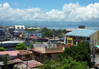
General Santos sits along Sarangani Bay on the southern coast of Mindanao and serves as a central shipping hub for southern Mindanao. The city stretches along the coastline with a national port, industrial zones, and residential districts extending toward the interior.
General Paulino Santos brought a few dozen families from Luzon here in 1939 to establish a farming settlement on the Sarangani shore. The settlement grew rapidly after World War II and developed into a major fishing center named after its founder.
Locals still call the city Dadiangas, a name from the B'laan language that refers to thorny trees once common across the area. This name remains in everyday use and shows the connection between earlier inhabitants and today's port center.
The city sits roughly two flight hours south of Manila and is accessible by road from other parts of Mindanao. The port and fishing zone are located along the shore, while main streets run through the business district and provide access to residential areas.
The fishing facility at Barangay Tambler processes fresh tuna fit for sashimi daily and employs thousands of people in the cold chain. The facilities operate around the clock and ship the catch directly to international markets, making the city a key node for seafood.
Location: Soccsksargen
Inception: August 18, 1947
Elevation above the sea: 197 m
Shares border with: Malungon, Alabel, Malapatan
Phone: +63833021164
Website: http://gensantos.gov.ph
GPS coordinates: 6.11667,125.16667
Latest update: December 4, 2025 19:03
Mount Apo
97.6 km
Mount Matutum
28.9 km
San Pedro Cathedral
116.3 km
Fort Pikit
118.2 km
Davao River Bridge
119.8 km
Isla Reta Beach Resort
109.8 km
Mount Apo Natural Park
97.6 km
D' Bone Collector Museum
116.1 km
Museo Dabawenyo
114.7 km
Pacman Beach Resort Complex
24.3 km
Coco Beach Resort
36.8 km
Fuerte de Reina Regente
124 km
Costa Marina Beach Resort
122.3 km
Burial Site of the Seventeen Filipino Martyrs of Koronadal historical marker
55.7 km
Mount Parker
30.7 km
Davao City Hall historical marker
116.3 km
Princess del Leonor Hotel Resort and Convention Center
50.4 km
Gen. Paulino Santos historical marker
779 m
Andres Bonifacio historical marker
106.9 km
Davao Museum of History and Ethnography
122.2 km
Ohta Kyozaburo historical marker
114.9 km
Museyo Kutawato
107.5 km
KCC Cinema
55.1 km
Koronadal Cathedral
55.6 km
Wasag Beach
113.1 km
Port Sta. Ana historical marker
118.2 km
Ruins of Fort Marorong historical marker
83.3 km
Balnunto Falls
53.8 kmReviews
Visited this place? Tap the stars to rate it and share your experience / photos with the community! Try now! You can cancel it anytime.
Discover hidden gems everywhere you go!
From secret cafés to breathtaking viewpoints, skip the crowded tourist spots and find places that match your style. Our app makes it easy with voice search, smart filtering, route optimization, and insider tips from travelers worldwide. Download now for the complete mobile experience.
A unique approach to discovering new places❞
— Le Figaro
All the places worth exploring❞
— France Info
A tailor-made excursion in just a few clicks❞
— 20 Minutes