Enable Location

We need your location to show you interesting places around you

Discover nearby places

Find interesting locations and hidden gems around you

Precise directions

Get accurate directions and distances to places

Your location is never shared with other users. It's only used when you tap the location button.

Smokey Mountain

Log in to your account

Start exploring — it's free

Trusted by 68,949 travelers worldwide

Continue with Google
Continue with Apple
or

We will send you a code to connect

By continuing, you accept our Terms and Conditions and our Privacy Policy

Check your inbox

We've sent a pincode in your inbox. Please enter the code below.

Smokey Mountain
Discussion Reviews 2 Photos
36.5k Popularity

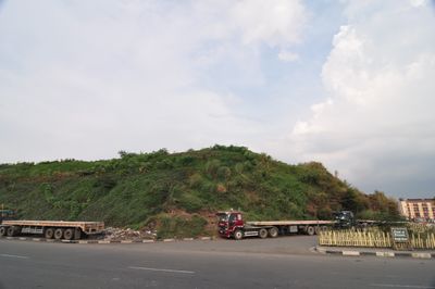
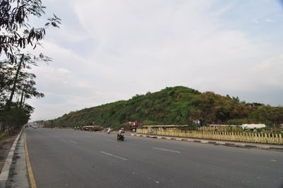
Smokey Mountain, Landfill site in Tondo, Manila, Philippines

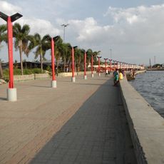
Smokey Mountain is a former landfill in Tondo, Manila that once received thousands of tons of waste annually from the metropolitan area. The site eventually transformed into a residential neighborhood after being closed and developed by local authorities.

The site operated as Manila's primary waste disposal location for decades before authorities began transitioning it into residential space. Development efforts reflected broader changes in how the city attempted to address informal settlements and waste management challenges.

The location influenced Filipino arts, including the formation of a musical group named after the site that addressed social and environmental topics.

The location is now a residential neighborhood that visitors can explore like any other area of Manila. Keep in mind the site continues to develop and is home to established communities with their own daily routines.

The place got its name from plumes of smoke rising when decomposing waste underground ignited from internal heat and chemical reactions. These fires burned intermittently for years, creating the distinctive smoke that gave the landfill its identity.

The community of curious travelers

AroundUs brings together thousands of curated places, local tips, and hidden gems, enriched daily by 60,000 contributors worldwide.

Start exploring
GPS coordinates
14.63222,120.96028
Latest update
December 17, 2025 10:53
Around this place
Divisoria
Philippines

Divisoria

3.2 km
Caloocan Cathedral
Philippines

Caloocan Cathedral

2.6 km

Navotas Centennial Park
Philippines

Navotas Centennial Park

2.5 km
Plaza Vicente del Fierro
Philippines

Plaza Vicente del Fierro

1.2 km
Timoteo Paez historical marker
Philippines

Timoteo Paez historical marker

742 m
La Liga Filipina historical marker
Philippines

La Liga Filipina historical marker

3 km
Vicente L. del Fierro historical marker
Philippines

Vicente L. del Fierro historical marker

1.2 km
Department of Health Central Office
Philippines

Department of Health Central Office

2.9 km
Domingo Franco y Tuason historical marker
Philippines

Domingo Franco y Tuason historical marker

2.6 km
Former Burial Site of Apolinario Mabini historical marker
Philippines

Former Burial Site of Apolinario Mabini historical marker

2.8 km
Amado Hernandez y Vera historical marker
Philippines

Amado Hernandez y Vera historical marker

2.8 km
Honorio Lopez historical marker
Philippines

Honorio Lopez historical marker

2.4 km
Severino Reyes historical marker
Philippines

Severino Reyes historical marker

2.6 km
Church of San Bartolome historical marker
Philippines

Church of San Bartolome historical marker

3.1 km
Church of Tondo historical marker
Philippines

Church of Tondo historical marker

2.8 km
Honorio Lopez historical marker
Philippines

Honorio Lopez historical marker

2.6 km
Mary Johnston Hospital historical marker
Philippines

Mary Johnston Hospital historical marker

2.6 km
Sixto Ylagan Orosa y Agoncillo historical marker
Philippines

Sixto Ylagan Orosa y Agoncillo historical marker

2.9 km
Memorare historical marker (Battle of Bangkusay)
Philippines

Memorare historical marker (Battle of Bangkusay)

2.6 km
Iglesia Evangelica Metodista en las Islas Filipinas historical marker
Philippines

Iglesia Evangelica Metodista en las Islas Filipinas historical marker

2.3 km
Chinese-Filipino Anti-Japanese Guerrilla Forces in the Philippines historical marker
Philippines

Chinese-Filipino Anti-Japanese Guerrilla Forces in the Philippines historical marker

2.6 km
Jose F. Fabella historical marker
Philippines

Jose F. Fabella historical marker

3 km
Philippines

Vitas Estero

702 m
Cathedral of Caloocan historical marker
Philippines

Cathedral of Caloocan historical marker

2.5 km
San Lazaro Hospital historical marker
Philippines

San Lazaro Hospital historical marker

3.1 km
Department of Health historical marker
Philippines

Department of Health historical marker

3 km
Francis Burton Harrison historical marker
Philippines

Francis Burton Harrison historical marker

3 km
Show the full map
Reviews
Share your experience

No review yet

Discussions
Start a discussion...

No discussion yet

« Smokey Mountain - Landfill site in Tondo, Manila, Philippines » is provided by Around Us (aroundus.com). Images and texts are derived from Wikimedia project under a Creative Commons license. You are allowed to copy, distribute, and modify copies of this page, under the conditions set by the license, as long as this note is clearly visible.

Discover hidden gems everywhere you go!

From secret cafés to breathtaking viewpoints, skip the crowded tourist spots and find places that match your style. Our app makes it easy with voice search, smart filtering, route optimization, and insider tips from travelers worldwide. Download now for the complete mobile experience.

Around Us App Screenshot

A unique approach to discovering new places

Le Figaro

All the places worth exploring

France Info

A tailor-made excursion in just a few clicks

20 Minutes

Around Us
Travel Guide & Maps
Download

Send to your phone

QR Code
1

Open the camera app on your mobile.

2

Point at the QR code with your camera. A notification will appear.

3

Tap the notification to open the link.