Caramoan, Municipality in Camarines Sur, Philippines.
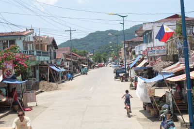
Caramoan is a municipality on the southeastern peninsula of the Bicol Region with more than 70 kilometers of coastline facing the Philippine Sea. The territory includes a main landmass and numerous offshore islands that form an intricate network of bays, beaches, and limestone ridges.
The first settlement was established in 1619 by Spanish missionary Francisco de la Cruz Y Oropesa, replacing the earlier Dutch-named location. This founding moment marks when European settlement and Spanish administration began in this place.
The Feast of St. Michael the Archangel brings the community together with processions, religious services, and competitions that shape the local calendar. This celebration shows how faith remains woven into everyday life here.
The easiest way to arrive is from Naga City by land transport, then switching to boats to reach the surrounding islands and beaches. Plan your visit during drier months when waters are calmer and boat trips are more comfortable.
Multiple international versions of the television show Survivor filmed their seasons here, using the limestone formations and remote beaches as backdrops. These productions brought global attention to specific locations, though most visitors remain unaware of this filming history.
Location: Camarines Sur
Elevation above the sea: 14.1 m
Shares border with: Garchitorena
GPS coordinates: 13.77070,123.86310
Latest update: December 6, 2025 22:04
Mayon Volcano
60.4 km
Mount Isarog
54.5 km
Mount Iriga
56.3 km
Mayon Volcano Natural Park
60.4 km
Mount Masaraga
58.6 km
Tabaco Church
48 km
Buhi Church
53.1 km
Baao Church
64.2 km
Smith, Bell and Company House
47.9 km
Mount Isarog Natural Park
53.6 km
Panicuason Hot Springs Resort
59.7 km
Tabaco City Hall
48 km
Iglesia ni Cristo chapel, Nabua, Bicol
66.5 km
Jorge Barlin é Imperial historical marker
64.3 km
Virac Cathedral
45.1 km
Angela Manalang Gloria historical marker
47.9 km
Commercial Building of Smith, Bell & Co. Tabaco, Albay historical marker
47.9 km
Philtranco Transport Heritage Museum
61.7 km
Jorge Barlin Monument
64.3 km
Potenciano V. Gregorio Sr. historical marker
60.2 km
Tabaco Presidencia Building historical marker
48 km
Iriga Church
62.4 km
Church of Calabanga historical marker
70.3 km
Church of Baao historical marker
64.3 km
Philtranco Service Enterprises, Inc. historical marker
61.6 km
Church of Bato historical marker
50.2 km
Church of Iriga historical marker
62.4 km
Church of Buhi historical marker
53 kmVisited this place? Tap the stars to rate it and share your experience / photos with the community! Try now! You can cancel it anytime.
Discover hidden gems everywhere you go!
From secret cafés to breathtaking viewpoints, skip the crowded tourist spots and find places that match your style. Our app makes it easy with voice search, smart filtering, route optimization, and insider tips from travelers worldwide. Download now for the complete mobile experience.
A unique approach to discovering new places❞
— Le Figaro
All the places worth exploring❞
— France Info
A tailor-made excursion in just a few clicks❞
— 20 Minutes